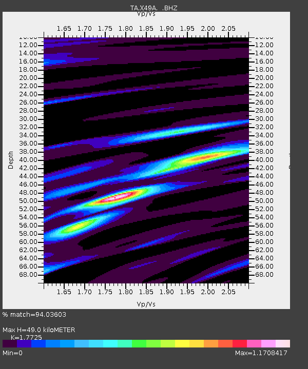
X49A Woodville, AR, USA - Earthquake Result Viewer

Earthquake location: Fox Islands, Aleutian Islands
Earthquake latitude/longitude: 52.6/-167.4
Earthquake time(UTC): 2012/08/10 (223) 18:37:43 GMT
Earthquake Depth: 13 km
Earthquake Magnitude: 5.9 MB, 6.2 MS, 6.2 MW, 6.2 MW
Earthquake Catalog/Contributor: WHDF/NEIC
Network: TA USArray Transportable Network (new EarthScope stations)
Station: X49A Woodville, AR, USA
Lat/Lon: 34.51 N/86.33 W
Elevation: 182 m
Distance: 58.3 deg
Az: 73.451 deg
Baz: 314.967 deg
Ray Param: 0.06290885
Estimated Moho Depth: 49.0 km
Estimated Crust Vp/Vs: 1.77
Assumed Crust Vp: 6.476 km/s
Estimated Crust Vs: 3.654 km/s
Estimated Crust Poisson's Ratio: 0.27
Radial Match: 94.03603 %
Radial Bump: 400
Transverse Match: 65.76405 %
Transverse Bump: 400
SOD ConfigId: 469095
Insert Time: 2013-02-22 06:09:09.257 +0000
GWidth: 2.5
Max Bumps: 400
Tol: 0.001

Signal To Noise

ChannelStoNSTALTA
TA:X49A: :BHZ:20120810T18:47:06.60001Z5.2050653.6623732E-77.0361715E-8
TA:X49A: :BHN:20120810T18:47:06.60001Z2.63584421.2671887E-74.807525E-8
TA:X49A: :BHE:20120810T18:47:06.60001Z3.46110461.7866469E-75.1620717E-8
Arrivals
Ps6.1 SECOND
PpPs20 SECOND
PsPs/PpSs26 SECOND