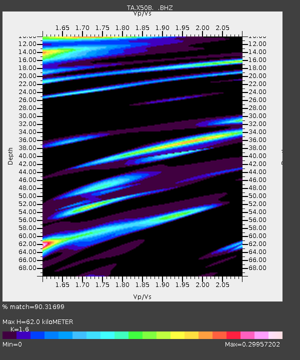
X50B Fort Payne, AL, USA - Earthquake Result Viewer
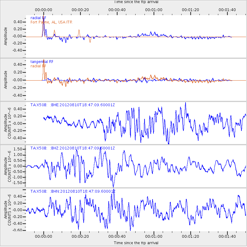
Earthquake location: Fox Islands, Aleutian Islands
Earthquake latitude/longitude: 52.6/-167.4
Earthquake time(UTC): 2012/08/10 (223) 18:37:43 GMT
Earthquake Depth: 13 km
Earthquake Magnitude: 5.9 MB, 6.2 MS, 6.2 MW, 6.2 MW
Earthquake Catalog/Contributor: WHDF/NEIC
Network: TA USArray Transportable Network (new EarthScope stations)
Station: X50B Fort Payne, AL, USA
Lat/Lon: 34.46 N/85.65 W
Elevation: 494 m
Distance: 58.8 deg
Az: 73.03 deg
Baz: 315.129 deg
Ray Param: 0.06262796
Estimated Moho Depth: 62.0 km
Estimated Crust Vp/Vs: 1.60
Assumed Crust Vp: 6.35 km/s
Estimated Crust Vs: 3.969 km/s
Estimated Crust Poisson's Ratio: 0.18
Radial Match: 90.31699 %
Radial Bump: 400
Transverse Match: 78.062096 %
Transverse Bump: 400
SOD ConfigId: 469095
Insert Time: 2013-02-22 06:09:21.025 +0000
GWidth: 2.5
Max Bumps: 400
Tol: 0.001

Signal To Noise

ChannelStoNSTALTA
TA:X50B: :BHZ:20120810T18:47:09.60001Z5.494794.9542336E-79.0162374E-8
TA:X50B: :BHN:20120810T18:47:09.60001Z2.4387881.8888385E-77.744988E-8
TA:X50B: :BHE:20120810T18:47:09.60001Z2.26437832.0513009E-79.059002E-8
Arrivals
Ps6.2 SECOND
PpPs24 SECOND
PsPs/PpSs30 SECOND