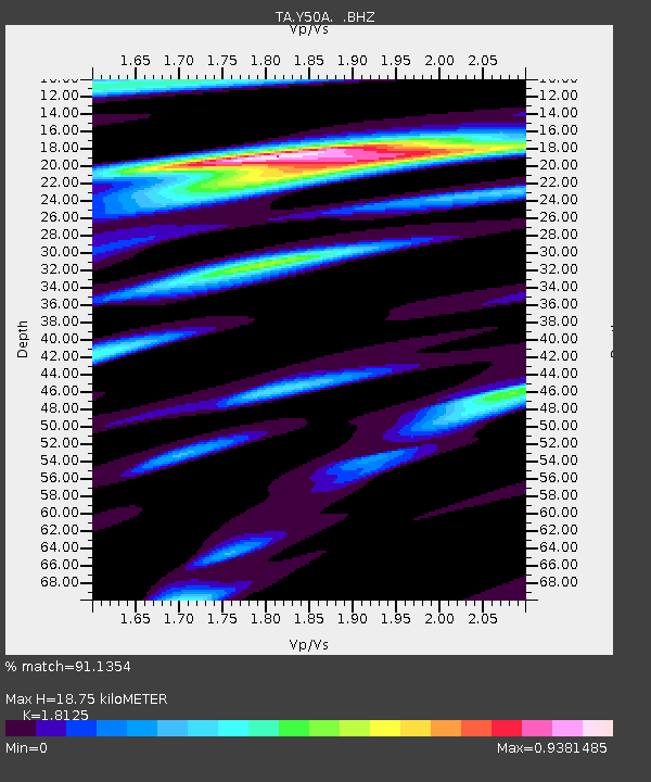
Y50A Piedmont, AL, USA - Earthquake Result Viewer
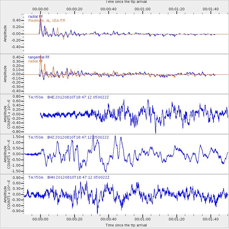
Earthquake location: Fox Islands, Aleutian Islands
Earthquake latitude/longitude: 52.6/-167.4
Earthquake time(UTC): 2012/08/10 (223) 18:37:43 GMT
Earthquake Depth: 13 km
Earthquake Magnitude: 5.9 MB, 6.2 MS, 6.2 MW, 6.2 MW
Earthquake Catalog/Contributor: WHDF/NEIC
Network: TA USArray Transportable Network (new EarthScope stations)
Station: Y50A Piedmont, AL, USA
Lat/Lon: 33.89 N/85.73 W
Elevation: 248 m
Distance: 59.1 deg
Az: 73.556 deg
Baz: 315.352 deg
Ray Param: 0.062396046
Estimated Moho Depth: 18.75 km
Estimated Crust Vp/Vs: 1.81
Assumed Crust Vp: 6.719 km/s
Estimated Crust Vs: 3.707 km/s
Estimated Crust Poisson's Ratio: 0.28
Radial Match: 91.1354 %
Radial Bump: 400
Transverse Match: 54.85593 %
Transverse Bump: 400
SOD ConfigId: 469095
Insert Time: 2013-02-22 06:09:35.608 +0000
GWidth: 2.5
Max Bumps: 400
Tol: 0.001

Signal To Noise

ChannelStoNSTALTA
TA:Y50A: :BHZ:20120810T18:47:12.050022Z8.0862684.3825867E-75.419789E-8
TA:Y50A: :BHN:20120810T18:47:12.050022Z1.60572621.4869285E-79.260162E-8
TA:Y50A: :BHE:20120810T18:47:12.050022Z1.76285651.1123E-76.309646E-8
Arrivals
Ps2.4 SECOND
PpPs7.5 SECOND
PsPs/PpSs9.8 SECOND