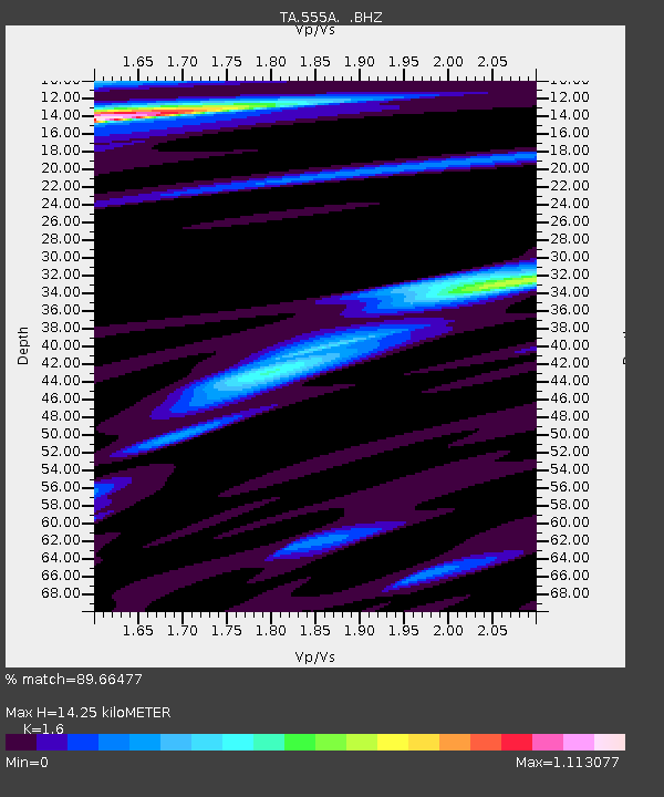
555A McAlpin, FL, USA - Earthquake Result Viewer
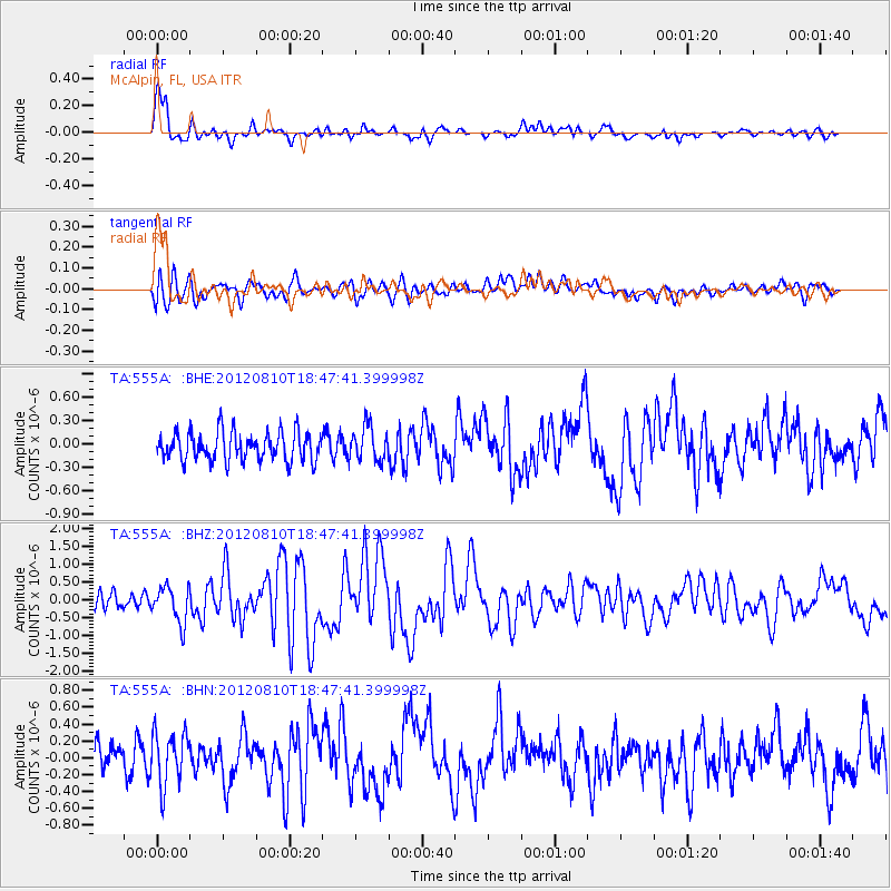
Earthquake location: Fox Islands, Aleutian Islands
Earthquake latitude/longitude: 52.6/-167.4
Earthquake time(UTC): 2012/08/10 (223) 18:37:43 GMT
Earthquake Depth: 13 km
Earthquake Magnitude: 5.9 MB, 6.2 MS, 6.2 MW, 6.2 MW
Earthquake Catalog/Contributor: WHDF/NEIC
Network: TA USArray Transportable Network (new EarthScope stations)
Station: 555A McAlpin, FL, USA
Lat/Lon: 30.12 N/82.97 W
Elevation: 29 m
Distance: 63.5 deg
Az: 74.575 deg
Baz: 317.303 deg
Ray Param: 0.059558775
Estimated Moho Depth: 14.25 km
Estimated Crust Vp/Vs: 1.60
Assumed Crust Vp: 6.565 km/s
Estimated Crust Vs: 4.103 km/s
Estimated Crust Poisson's Ratio: 0.18
Radial Match: 89.66477 %
Radial Bump: 400
Transverse Match: 64.14729 %
Transverse Bump: 400
SOD ConfigId: 469095
Insert Time: 2013-02-22 06:11:33.332 +0000
GWidth: 2.5
Max Bumps: 400
Tol: 0.001

Signal To Noise

ChannelStoNSTALTA
TA:555A: :BHZ:20120810T18:47:41.399998Z2.51743535.088151E-72.0211648E-7
TA:555A: :BHN:20120810T18:47:41.399998Z2.2142953.1791004E-71.4357168E-7
TA:555A: :BHE:20120810T18:47:41.399998Z1.21430282.2267194E-71.8337433E-7
Arrivals
Ps1.4 SECOND
PpPs5.4 SECOND
PsPs/PpSs6.7 SECOND