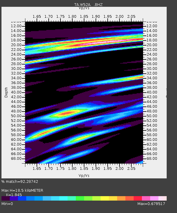
W52A Murphy, NC, USA - Earthquake Result Viewer
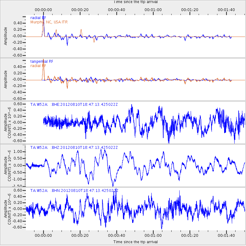
Earthquake location: Fox Islands, Aleutian Islands
Earthquake latitude/longitude: 52.6/-167.4
Earthquake time(UTC): 2012/08/10 (223) 18:37:43 GMT
Earthquake Depth: 13 km
Earthquake Magnitude: 5.9 MB, 6.2 MS, 6.2 MW, 6.2 MW
Earthquake Catalog/Contributor: WHDF/NEIC
Network: TA USArray Transportable Network (new EarthScope stations)
Station: W52A Murphy, NC, USA
Lat/Lon: 35.09 N/83.93 W
Elevation: 519 m
Distance: 59.3 deg
Az: 71.339 deg
Baz: 315.236 deg
Ray Param: 0.062265333
Estimated Moho Depth: 18.5 km
Estimated Crust Vp/Vs: 1.95
Assumed Crust Vp: 6.35 km/s
Estimated Crust Vs: 3.265 km/s
Estimated Crust Poisson's Ratio: 0.32
Radial Match: 92.28742 %
Radial Bump: 396
Transverse Match: 69.344246 %
Transverse Bump: 400
SOD ConfigId: 469095
Insert Time: 2013-02-22 06:13:44.361 +0000
GWidth: 2.5
Max Bumps: 400
Tol: 0.001

Signal To Noise

ChannelStoNSTALTA
TA:W52A: :BHZ:20120810T18:47:13.425022Z3.63674743.5910614E-79.874377E-8
TA:W52A: :BHN:20120810T18:47:13.425022Z1.51228651.2132949E-78.0229164E-8
TA:W52A: :BHE:20120810T18:47:13.425022Z1.55193321.6278537E-71.04891996E-7
Arrivals
Ps2.9 SECOND
PpPs8.2 SECOND
PsPs/PpSs11 SECOND