You are here: Home > Network List > G - GEOSCOPE Stations List
> Station TAM Tamanrasset, Algeria > Earthquake Result Viewer
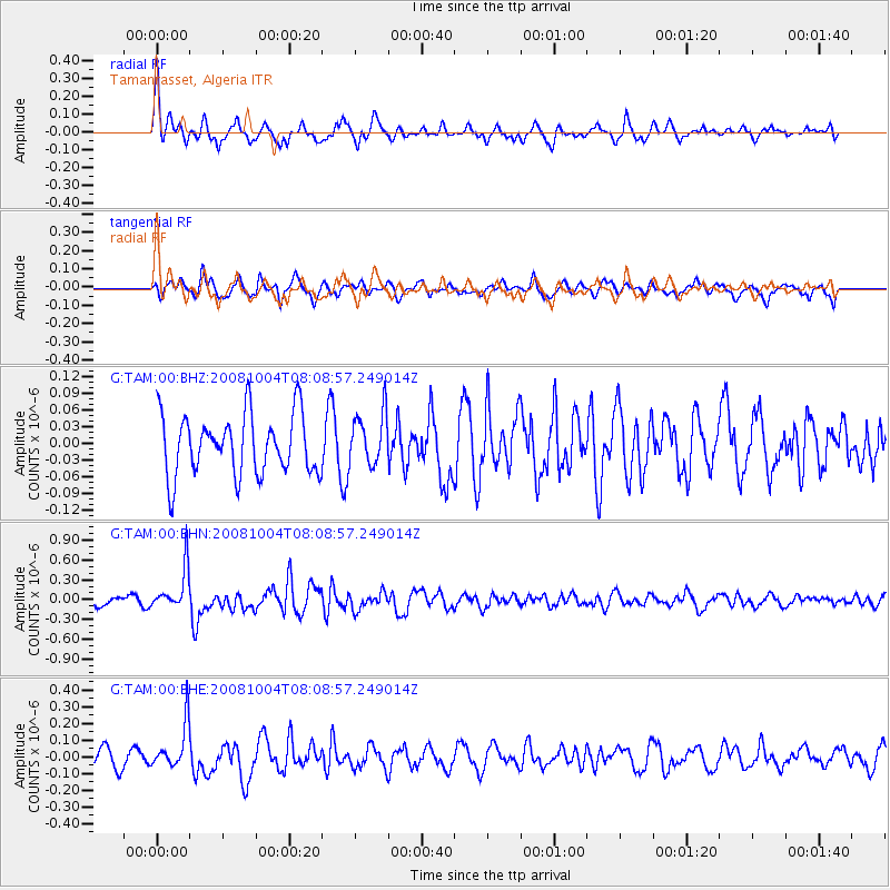
TAM Tamanrasset, Algeria - Earthquake Result Viewer
*The percent match for this event was below the threshold and hence no stack was calculated.
| Earthquake location: |
South Sandwich Islands Region |
| Earthquake latitude/longitude: |
-59.3/-25.9 |
| Earthquake time(UTC): |
2008/10/04 (278) 07:56:52 GMT |
| Earthquake Depth: |
35 km |
| Earthquake Magnitude: |
5.8 MB, 5.3 MS, 5.7 MW, 5.6 MW |
| Earthquake Catalog/Contributor: |
WHDF/NEIC |
|
| Network: |
G GEOSCOPE |
| Station: |
TAM Tamanrasset, Algeria |
| Lat/Lon: |
22.79 N/5.53 E |
| Elevation: |
1377 m |
|
| Distance: |
85.8 deg |
| Az: |
28.849 deg |
| Baz: |
195.542 deg |
| Ray Param: |
$rayparam |
*The percent match for this event was below the threshold and hence was not used in the summary stack. |
|
| Radial Match: |
58.15722 % |
| Radial Bump: |
338 |
| Transverse Match: |
55.313038 % |
| Transverse Bump: |
400 |
| SOD ConfigId: |
2556 |
| Insert Time: |
2010-02-27 00:35:08.096 +0000 |
| GWidth: |
2.5 |
| Max Bumps: |
400 |
| Tol: |
0.001 |
|
Signal To Noise
| Channel | StoN | STA | LTA |
| G:TAM:00:BHN:20081004T08:08:57.249014Z | 4.6190147 | 3.1548691E-7 | 6.830177E-8 |
| G:TAM:00:BHE:20081004T08:08:57.249014Z | 1.6463302 | 1.3279958E-7 | 8.0664E-8 |
| G:TAM:00:BHZ:20081004T08:08:57.249014Z | 0.85944366 | 4.680977E-8 | 5.4465197E-8 |
| Arrivals |
| Ps | |
| PpPs | |
| PsPs/PpSs | |


