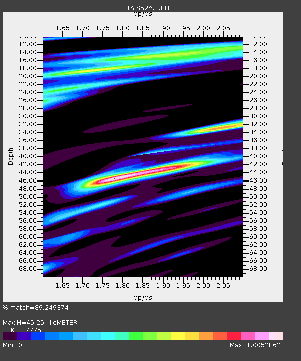
S52A Salyersville, KY, USA - Earthquake Result Viewer
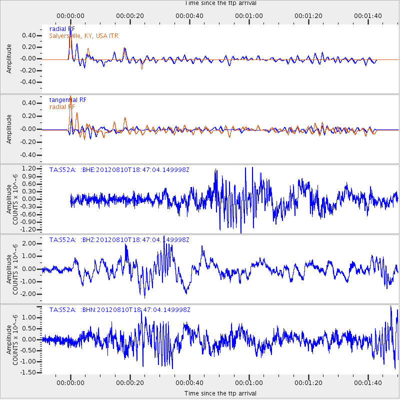
Earthquake location: Fox Islands, Aleutian Islands
Earthquake latitude/longitude: 52.6/-167.4
Earthquake time(UTC): 2012/08/10 (223) 18:37:43 GMT
Earthquake Depth: 13 km
Earthquake Magnitude: 5.9 MB, 6.2 MS, 6.2 MW, 6.2 MW
Earthquake Catalog/Contributor: WHDF/NEIC
Network: TA USArray Transportable Network (new EarthScope stations)
Station: S52A Salyersville, KY, USA
Lat/Lon: 37.68 N/83.08 W
Elevation: 367 m
Distance: 58.0 deg
Az: 68.629 deg
Baz: 314.328 deg
Ray Param: 0.06313616
Estimated Moho Depth: 45.25 km
Estimated Crust Vp/Vs: 1.78
Assumed Crust Vp: 6.476 km/s
Estimated Crust Vs: 3.643 km/s
Estimated Crust Poisson's Ratio: 0.27
Radial Match: 89.249374 %
Radial Bump: 400
Transverse Match: 58.24967 %
Transverse Bump: 400
SOD ConfigId: 469095
Insert Time: 2013-02-22 06:14:36.855 +0000
GWidth: 2.5
Max Bumps: 400
Tol: 0.001

Signal To Noise

ChannelStoNSTALTA
TA:S52A: :BHZ:20120810T18:47:04.149998Z4.5183525.504504E-71.2182548E-7
TA:S52A: :BHN:20120810T18:47:04.149998Z1.08689451.666942E-71.5336742E-7
TA:S52A: :BHE:20120810T18:47:04.149998Z1.60485321.9306911E-71.2030328E-7
Arrivals
Ps5.7 SECOND
PpPs18 SECOND
PsPs/PpSs24 SECOND