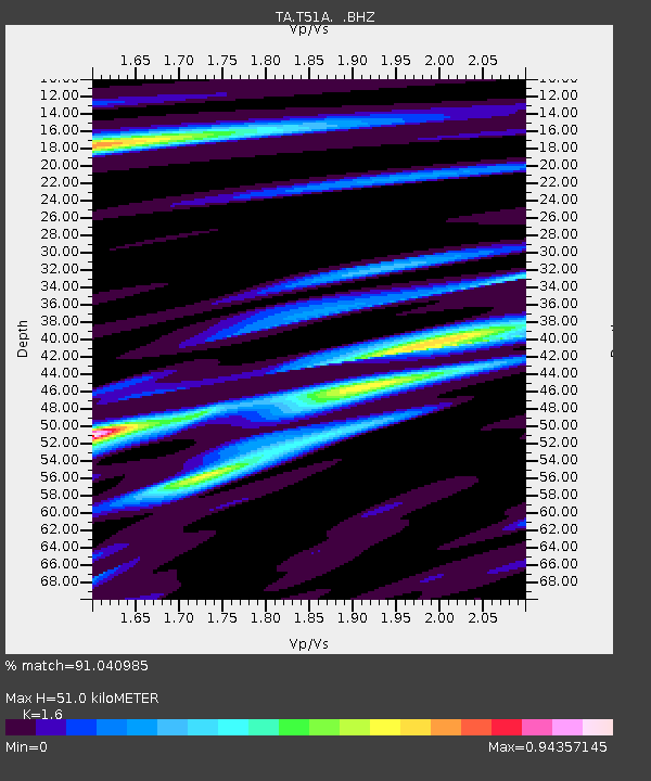
T51A Gray, KY, USA - Earthquake Result Viewer

Earthquake location: Fox Islands, Aleutian Islands
Earthquake latitude/longitude: 52.6/-167.4
Earthquake time(UTC): 2012/08/10 (223) 18:37:43 GMT
Earthquake Depth: 13 km
Earthquake Magnitude: 5.9 MB, 6.2 MS, 6.2 MW, 6.2 MW
Earthquake Catalog/Contributor: WHDF/NEIC
Network: TA USArray Transportable Network (new EarthScope stations)
Station: T51A Gray, KY, USA
Lat/Lon: 36.97 N/83.95 W
Elevation: 329 m
Distance: 58.0 deg
Az: 69.799 deg
Baz: 314.425 deg
Ray Param: 0.06313346
Estimated Moho Depth: 51.0 km
Estimated Crust Vp/Vs: 1.60
Assumed Crust Vp: 6.476 km/s
Estimated Crust Vs: 4.047 km/s
Estimated Crust Poisson's Ratio: 0.18
Radial Match: 91.040985 %
Radial Bump: 400
Transverse Match: 56.40845 %
Transverse Bump: 400
SOD ConfigId: 469095
Insert Time: 2013-02-22 06:15:35.439 +0000
GWidth: 2.5
Max Bumps: 400
Tol: 0.001

Signal To Noise

ChannelStoNSTALTA
TA:T51A: :BHZ:20120810T18:47:04.199985Z5.72960573.5601153E-76.2135435E-8
TA:T51A: :BHN:20120810T18:47:04.199985Z2.96554761.2036475E-74.0587697E-8
TA:T51A: :BHE:20120810T18:47:04.199985Z3.04018831.5277193E-75.025081E-8
Arrivals
Ps5.0 SECOND
PpPs19 SECOND
PsPs/PpSs24 SECOND