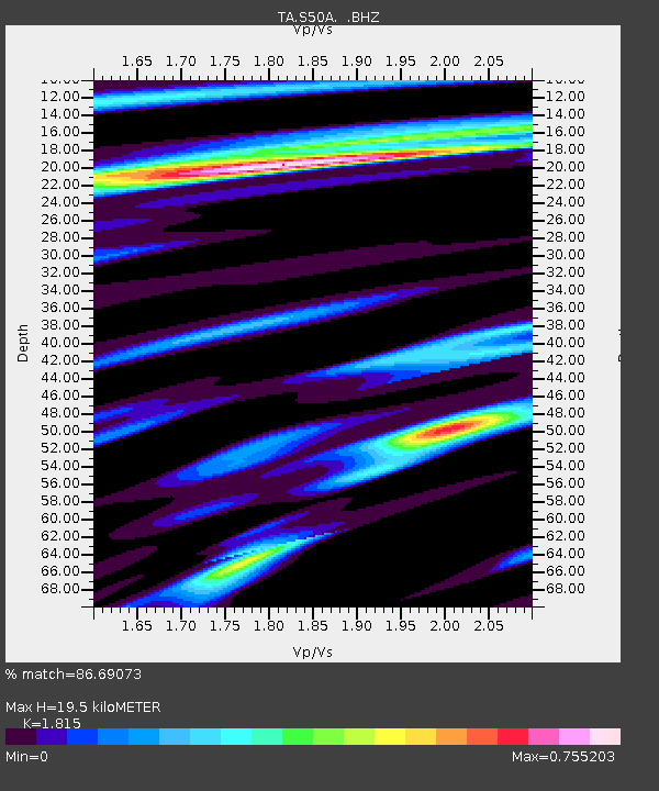
S50A Richmond, KY, USA - Earthquake Result Viewer
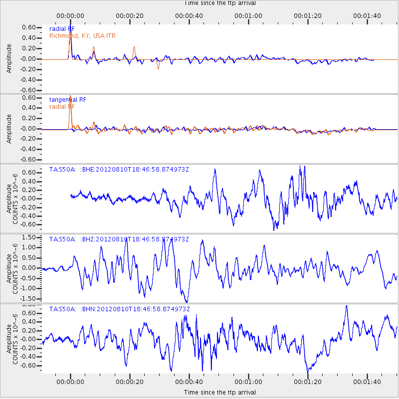
Earthquake location: Fox Islands, Aleutian Islands
Earthquake latitude/longitude: 52.6/-167.4
Earthquake time(UTC): 2012/08/10 (223) 18:37:43 GMT
Earthquake Depth: 13 km
Earthquake Magnitude: 5.9 MB, 6.2 MS, 6.2 MW, 6.2 MW
Earthquake Catalog/Contributor: WHDF/NEIC
Network: TA USArray Transportable Network (new EarthScope stations)
Station: S50A Richmond, KY, USA
Lat/Lon: 37.68 N/84.40 W
Elevation: 300 m
Distance: 57.2 deg
Az: 69.494 deg
Baz: 313.987 deg
Ray Param: 0.063617975
Estimated Moho Depth: 19.5 km
Estimated Crust Vp/Vs: 1.82
Assumed Crust Vp: 6.476 km/s
Estimated Crust Vs: 3.568 km/s
Estimated Crust Poisson's Ratio: 0.28
Radial Match: 86.69073 %
Radial Bump: 400
Transverse Match: 35.57646 %
Transverse Bump: 400
SOD ConfigId: 469095
Insert Time: 2013-02-22 06:15:40.298 +0000
GWidth: 2.5
Max Bumps: 400
Tol: 0.001

Signal To Noise

ChannelStoNSTALTA
TA:S50A: :BHZ:20120810T18:46:58.874973Z6.4365394.337029E-76.738138E-8
TA:S50A: :BHN:20120810T18:46:58.874973Z1.49963031.4354535E-79.572049E-8
TA:S50A: :BHE:20120810T18:46:58.874973Z2.50163081.4380302E-75.7483707E-8
Arrivals
Ps2.6 SECOND
PpPs8.1 SECOND
PsPs/PpSs11 SECOND