You are here: Home > Network List > TA - USArray Transportable Network (new EarthScope stations) Stations List
> Station P50A Jamestown, OH, USA > Earthquake Result Viewer
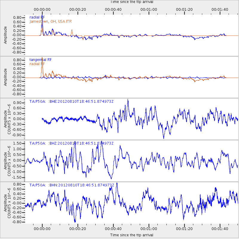
P50A Jamestown, OH, USA - Earthquake Result Viewer
*The percent match for this event was below the threshold and hence no stack was calculated.
| Earthquake location: |
Fox Islands, Aleutian Islands |
| Earthquake latitude/longitude: |
52.6/-167.4 |
| Earthquake time(UTC): |
2012/08/10 (223) 18:37:43 GMT |
| Earthquake Depth: |
13 km |
| Earthquake Magnitude: |
5.9 MB, 6.2 MS, 6.2 MW, 6.2 MW |
| Earthquake Catalog/Contributor: |
WHDF/NEIC |
|
| Network: |
TA USArray Transportable Network (new EarthScope stations) |
| Station: |
P50A Jamestown, OH, USA |
| Lat/Lon: |
39.61 N/83.80 W |
| Elevation: |
318 m |
|
| Distance: |
56.2 deg |
| Az: |
67.437 deg |
| Baz: |
313.232 deg |
| Ray Param: |
$rayparam |
*The percent match for this event was below the threshold and hence was not used in the summary stack. |
|
| Radial Match: |
71.88727 % |
| Radial Bump: |
400 |
| Transverse Match: |
69.97216 % |
| Transverse Bump: |
400 |
| SOD ConfigId: |
469095 |
| Insert Time: |
2013-02-22 06:16:10.815 +0000 |
| GWidth: |
2.5 |
| Max Bumps: |
400 |
| Tol: |
0.001 |
|
Signal To Noise
| Channel | StoN | STA | LTA |
| TA:P50A: :BHZ:20120810T18:46:51.874973Z | 3.4835572 | 3.9436597E-7 | 1.1320784E-7 |
| TA:P50A: :BHN:20120810T18:46:51.874973Z | 1.7685118 | 2.074143E-7 | 1.17281836E-7 |
| TA:P50A: :BHE:20120810T18:46:51.874973Z | 2.7486603 | 2.5301813E-7 | 9.2051444E-8 |
| Arrivals |
| Ps | |
| PpPs | |
| PsPs/PpSs | |


