O48A Farmland, IN, USA - Earthquake Result Viewer
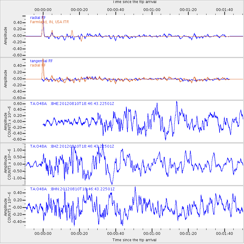
Earthquake location: Fox Islands, Aleutian Islands
Earthquake latitude/longitude: 52.6/-167.4
Earthquake time(UTC): 2012/08/10 (223) 18:37:43 GMT
Earthquake Depth: 13 km
Earthquake Magnitude: 5.9 MB, 6.2 MS, 6.2 MW, 6.2 MW
Earthquake Catalog/Contributor: WHDF/NEIC
Network: TA USArray Transportable Network (new EarthScope stations)
Station: O48A Farmland, IN, USA
Lat/Lon: 40.26 N/85.16 W
Elevation: 300 m
Distance: 55.0 deg
Az: 67.722 deg
Baz: 312.526 deg
Ray Param: 0.06505366
Estimated Moho Depth: 30.25 km
Estimated Crust Vp/Vs: 2.03
Assumed Crust Vp: 6.498 km/s
Estimated Crust Vs: 3.197 km/s
Estimated Crust Poisson's Ratio: 0.34
Radial Match: 84.45884 %
Radial Bump: 400
Transverse Match: 48.446903 %
Transverse Bump: 400
SOD ConfigId: 469095
Insert Time: 2013-02-22 06:16:34.040 +0000
GWidth: 2.5
Max Bumps: 400
Tol: 0.001

Signal To Noise

ChannelStoNSTALTA
TA:O48A: :BHZ:20120810T18:46:43.22501Z4.35843133.7321175E-78.562983E-8
TA:O48A: :BHN:20120810T18:46:43.22501Z1.96878811.6151348E-78.2037E-8
TA:O48A: :BHE:20120810T18:46:43.22501Z2.73093371.7731192E-76.4927214E-8
Arrivals
Ps5.0 SECOND
PpPs13 SECOND
PsPs/PpSs19 SECOND