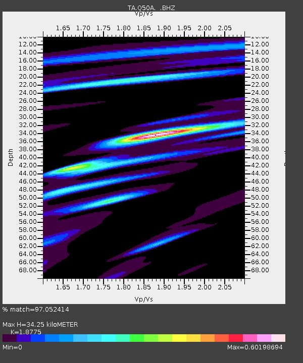
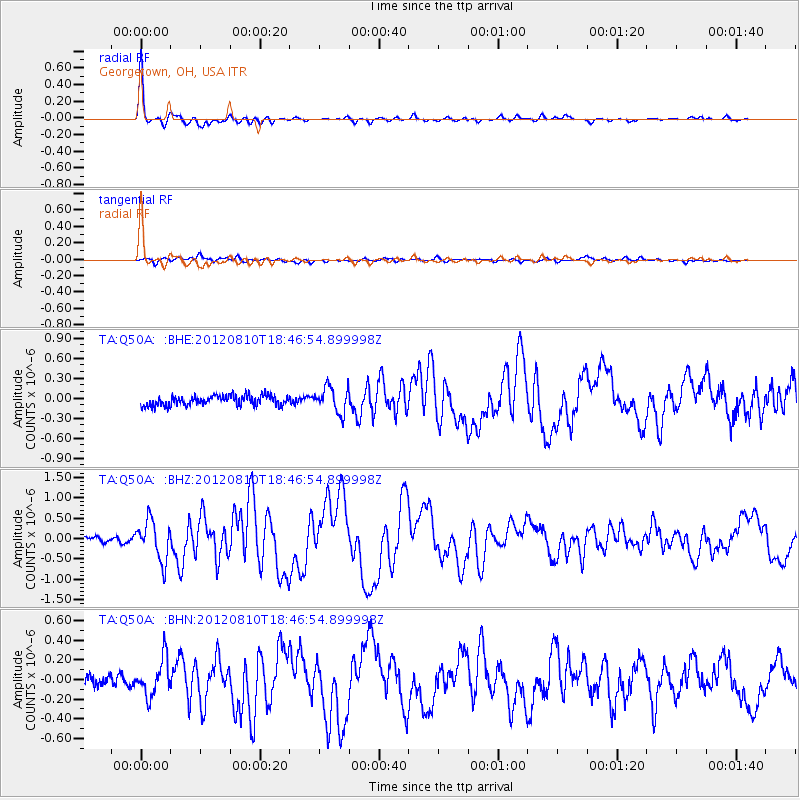
Q50A Georgetown, OH, USA - Earthquake Result Viewer

Earthquake location: Fox Islands, Aleutian Islands
Earthquake latitude/longitude: 52.6/-167.4
Earthquake time(UTC): 2012/08/10 (223) 18:37:43 GMT
Earthquake Depth: 13 km
Earthquake Magnitude: 5.9 MB, 6.2 MS, 6.2 MW, 6.2 MW
Earthquake Catalog/Contributor: WHDF/NEIC
Network: TA USArray Transportable Network (new EarthScope stations)
Station: Q50A Georgetown, OH, USA
Lat/Lon: 38.84 N/83.98 W
Elevation: 262 m
Distance: 56.7 deg
Az: 68.219 deg
Baz: 313.551 deg
Ray Param: 0.06398802
Estimated Moho Depth: 34.25 km
Estimated Crust Vp/Vs: 1.88
Assumed Crust Vp: 6.232 km/s
Estimated Crust Vs: 3.319 km/s
Estimated Crust Poisson's Ratio: 0.30
Radial Match: 97.052414 %
Radial Bump: 286
Transverse Match: 69.70594 %
Transverse Bump: 400
SOD ConfigId: 469095
Insert Time: 2013-02-22 06:16:44.093 +0000
GWidth: 2.5
Max Bumps: 400
Tol: 0.001

Signal To Noise

ChannelStoNSTALTA
TA:Q50A: :BHZ:20120810T18:46:54.899998Z6.47768074.8597235E-77.502259E-8
TA:Q50A: :BHN:20120810T18:46:54.899998Z3.24463631.8630078E-75.7418077E-8
TA:Q50A: :BHE:20120810T18:46:54.899998Z2.57177971.9318468E-77.5117114E-8
Arrivals
Ps5.0 SECOND
PpPs15 SECOND
PsPs/PpSs20 SECOND