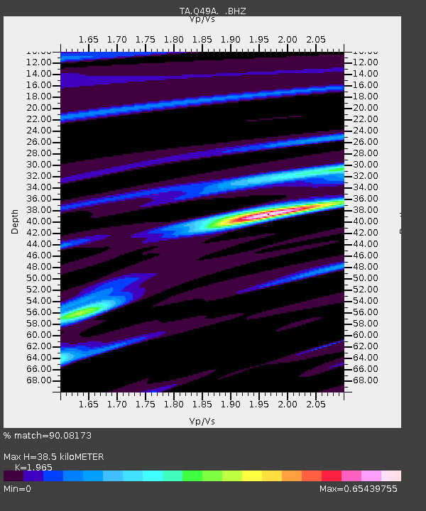
Q49A Aurora, IN, USA - Earthquake Result Viewer

Earthquake location: Fox Islands, Aleutian Islands
Earthquake latitude/longitude: 52.6/-167.4
Earthquake time(UTC): 2012/08/10 (223) 18:37:43 GMT
Earthquake Depth: 13 km
Earthquake Magnitude: 5.9 MB, 6.2 MS, 6.2 MW, 6.2 MW
Earthquake Catalog/Contributor: WHDF/NEIC
Network: TA USArray Transportable Network (new EarthScope stations)
Station: Q49A Aurora, IN, USA
Lat/Lon: 39.01 N/84.90 W
Elevation: 264 m
Distance: 56.0 deg
Az: 68.668 deg
Baz: 313.226 deg
Ray Param: 0.06439908
Estimated Moho Depth: 38.5 km
Estimated Crust Vp/Vs: 1.97
Assumed Crust Vp: 6.498 km/s
Estimated Crust Vs: 3.307 km/s
Estimated Crust Poisson's Ratio: 0.33
Radial Match: 90.08173 %
Radial Bump: 379
Transverse Match: 68.57014 %
Transverse Bump: 400
SOD ConfigId: 469095
Insert Time: 2013-02-22 06:16:50.824 +0000
GWidth: 2.5
Max Bumps: 400
Tol: 0.001

Signal To Noise

ChannelStoNSTALTA
TA:Q49A: :BHZ:20120810T18:46:50.399998Z3.84603553.5963902E-79.350902E-8
TA:Q49A: :BHN:20120810T18:46:50.399998Z2.1843751.5701849E-77.188257E-8
TA:Q49A: :BHE:20120810T18:46:50.399998Z2.19720581.7277905E-77.8635814E-8
Arrivals
Ps6.0 SECOND
PpPs17 SECOND
PsPs/PpSs23 SECOND