You are here: Home > Network List > G - GEOSCOPE Stations List
> Station TAM Tamanrasset, Algeria > Earthquake Result Viewer
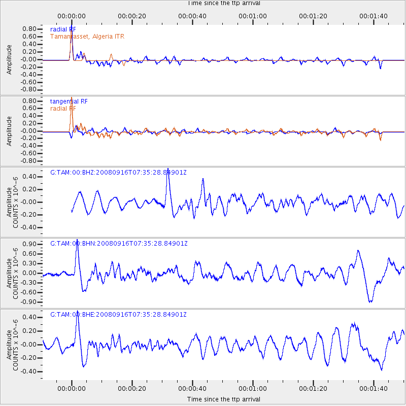
TAM Tamanrasset, Algeria - Earthquake Result Viewer
*The percent match for this event was below the threshold and hence no stack was calculated.
| Earthquake location: |
Central Mid-Atlantic Ridge |
| Earthquake latitude/longitude: |
0.9/-29.0 |
| Earthquake time(UTC): |
2008/09/16 (260) 07:28:25 GMT |
| Earthquake Depth: |
10 km |
| Earthquake Magnitude: |
5.8 MW, 5.2 MS, 5.2 MB, 5.8 MW |
| Earthquake Catalog/Contributor: |
WHDF/NEIC |
|
| Network: |
G GEOSCOPE |
| Station: |
TAM Tamanrasset, Algeria |
| Lat/Lon: |
22.79 N/5.53 E |
| Elevation: |
1377 m |
|
| Distance: |
40.0 deg |
| Az: |
54.489 deg |
| Baz: |
241.879 deg |
| Ray Param: |
$rayparam |
*The percent match for this event was below the threshold and hence was not used in the summary stack. |
|
| Radial Match: |
79.742035 % |
| Radial Bump: |
353 |
| Transverse Match: |
59.973057 % |
| Transverse Bump: |
400 |
| SOD ConfigId: |
2560 |
| Insert Time: |
2010-02-27 00:35:14.192 +0000 |
| GWidth: |
2.5 |
| Max Bumps: |
400 |
| Tol: |
0.001 |
|
Signal To Noise
| Channel | StoN | STA | LTA |
| G:TAM:00:BHN:20080916T07:35:28.84901Z | 4.710669 | 4.5590568E-7 | 9.678152E-8 |
| G:TAM:00:BHE:20080916T07:35:28.84901Z | 2.2133825 | 2.3512912E-7 | 1.0623067E-7 |
| G:TAM:00:BHZ:20080916T07:35:28.84901Z | 2.3620229 | 2.210296E-7 | 9.3576396E-8 |
| Arrivals |
| Ps | |
| PpPs | |
| PsPs/PpSs | |


