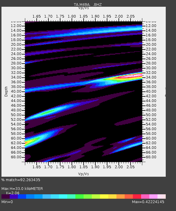
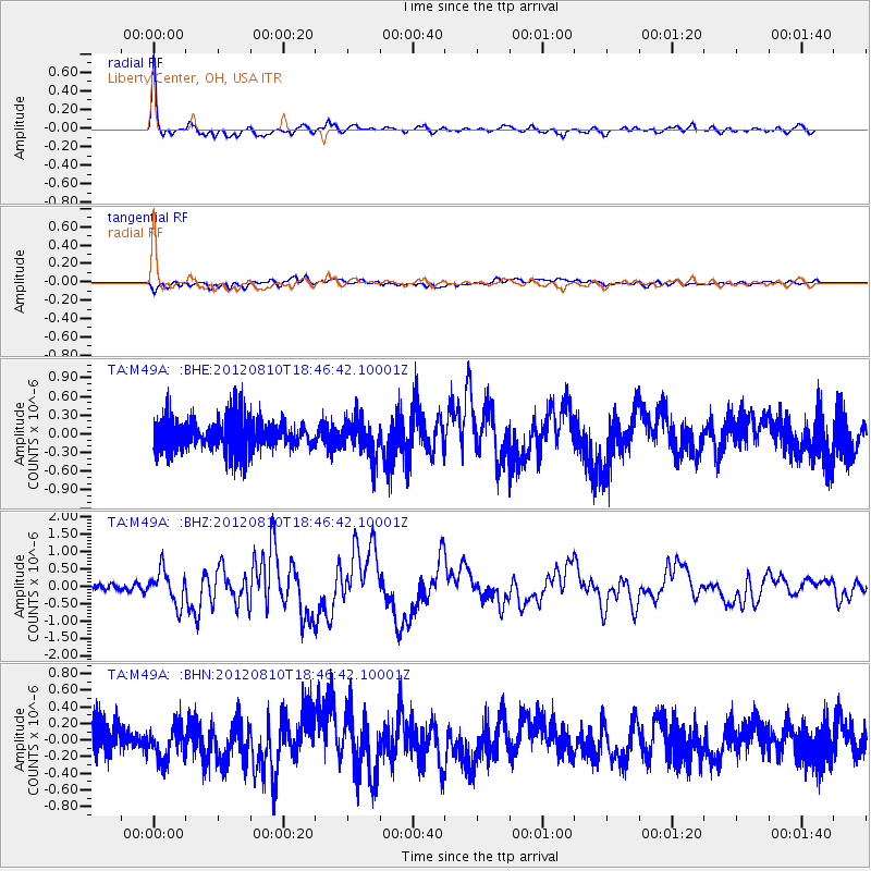
M49A Liberty Center, OH, USA - Earthquake Result Viewer

Earthquake location: Fox Islands, Aleutian Islands
Earthquake latitude/longitude: 52.6/-167.4
Earthquake time(UTC): 2012/08/10 (223) 18:37:43 GMT
Earthquake Depth: 13 km
Earthquake Magnitude: 5.9 MB, 6.2 MS, 6.2 MW, 6.2 MW
Earthquake Catalog/Contributor: WHDF/NEIC
Network: TA USArray Transportable Network (new EarthScope stations)
Station: M49A Liberty Center, OH, USA
Lat/Lon: 41.47 N/83.98 W
Elevation: 203 m
Distance: 54.9 deg
Az: 65.888 deg
Baz: 312.242 deg
Ray Param: 0.06515973
Estimated Moho Depth: 33.0 km
Estimated Crust Vp/Vs: 2.06
Assumed Crust Vp: 6.498 km/s
Estimated Crust Vs: 3.154 km/s
Estimated Crust Poisson's Ratio: 0.35
Radial Match: 92.263435 %
Radial Bump: 400
Transverse Match: 64.201355 %
Transverse Bump: 400
SOD ConfigId: 469095
Insert Time: 2013-02-22 06:17:24.525 +0000
GWidth: 2.5
Max Bumps: 400
Tol: 0.001

Signal To Noise

ChannelStoNSTALTA
TA:M49A: :BHZ:20120810T18:46:42.10001Z4.90898044.8250996E-79.829128E-8
TA:M49A: :BHN:20120810T18:46:42.10001Z0.96844281.9228601E-71.9855176E-7
TA:M49A: :BHE:20120810T18:46:42.10001Z1.15247562.951341E-72.5608708E-7
Arrivals
Ps5.6 SECOND
PpPs15 SECOND
PsPs/PpSs20 SECOND