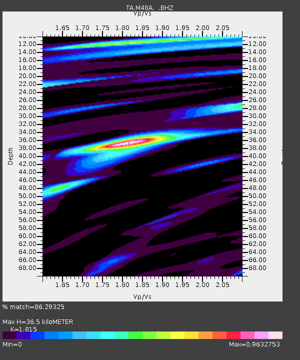
M48A Edgerton, OH, USA - Earthquake Result Viewer

Earthquake location: Fox Islands, Aleutian Islands
Earthquake latitude/longitude: 52.6/-167.4
Earthquake time(UTC): 2012/08/10 (223) 18:37:43 GMT
Earthquake Depth: 13 km
Earthquake Magnitude: 5.9 MB, 6.2 MS, 6.2 MW, 6.2 MW
Earthquake Catalog/Contributor: WHDF/NEIC
Network: TA USArray Transportable Network (new EarthScope stations)
Station: M48A Edgerton, OH, USA
Lat/Lon: 41.48 N/84.72 W
Elevation: 258 m
Distance: 54.5 deg
Az: 66.337 deg
Baz: 312.012 deg
Ray Param: 0.06543008
Estimated Moho Depth: 36.5 km
Estimated Crust Vp/Vs: 1.82
Assumed Crust Vp: 6.498 km/s
Estimated Crust Vs: 3.58 km/s
Estimated Crust Poisson's Ratio: 0.28
Radial Match: 86.29325 %
Radial Bump: 400
Transverse Match: 54.844254 %
Transverse Bump: 400
SOD ConfigId: 469095
Insert Time: 2013-02-22 06:17:42.316 +0000
GWidth: 2.5
Max Bumps: 400
Tol: 0.001

Signal To Noise

ChannelStoNSTALTA
TA:M48A: :BHZ:20120810T18:46:39.050022Z2.83230734.583164E-71.6181733E-7
TA:M48A: :BHN:20120810T18:46:39.050022Z1.22619811.5457357E-71.2605922E-7
TA:M48A: :BHE:20120810T18:46:39.050022Z1.82879342.2620821E-71.236926E-7
Arrivals
Ps4.8 SECOND
PpPs15 SECOND
PsPs/PpSs20 SECOND