You are here: Home > Network List > AK - Alaska Regional Network Stations List
> Station MDM Murphy Dome > Earthquake Result Viewer
MDM Murphy Dome - Earthquake Result Viewer
| Earthquake location: |
Xizang |
| Earthquake latitude/longitude: |
35.7/82.5 |
| Earthquake time(UTC): |
2012/08/12 (225) 10:47:06 GMT |
| Earthquake Depth: |
13 km |
| Earthquake Magnitude: |
6.1 MB, 6.1 MS, 6.2 MW, 6.3 MW |
| Earthquake Catalog/Contributor: |
WHDF/NEIC |
|
| Network: |
AK Alaska Regional Network |
| Station: |
MDM Murphy Dome |
| Lat/Lon: |
64.96 N/148.23 W |
| Elevation: |
634 m |
|
| Distance: |
72.2 deg |
| Az: |
20.253 deg |
| Baz: |
318.522 deg |
| Ray Param: |
0.053821724 |
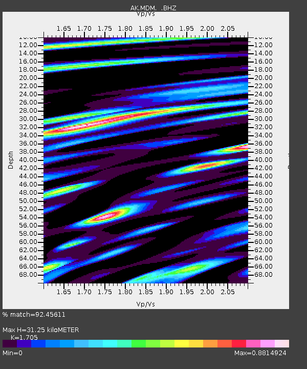
| Estimated Moho Depth: |
31.25 km |
| Estimated Crust Vp/Vs: |
1.71 |
| Assumed Crust Vp: |
6.566 km/s |
| Estimated Crust Vs: |
3.851 km/s |
| Estimated Crust Poisson's Ratio: |
0.24 |
|
| Radial Match: |
92.45611 % |
| Radial Bump: |
400 |
| Transverse Match: |
79.82623 % |
| Transverse Bump: |
400 |
| SOD ConfigId: |
469095 |
| Insert Time: |
2013-02-22 06:22:24.286 +0000 |
| GWidth: |
2.5 |
| Max Bumps: |
400 |
| Tol: |
0.001 |
|

Signal To Noise
| Channel | StoN | STA | LTA |
| AK:MDM: :BHZ:20120812T10:57:59.60802Z | 16.720753 | 8.07237E-7 | 4.8277546E-8 |
| AK:MDM: :BHN:20120812T10:57:59.60802Z | 3.7200358 | 2.3358686E-7 | 6.2791564E-8 |
| AK:MDM: :BHE:20120812T10:57:59.60802Z | 4.850892 | 2.1664742E-7 | 4.466136E-8 |
| Arrivals |
| Ps | 3.5 SECOND |
| PpPs | 12 SECOND |
| PsPs/PpSs | 16 SECOND |


