You are here: Home > Network List > CB - China National Seismic Network Stations List
> Station CN2 Changchun,Jilin Province > Earthquake Result Viewer
CN2 Changchun,Jilin Province - Earthquake Result Viewer
| Earthquake location: |
Xizang |
| Earthquake latitude/longitude: |
35.7/82.5 |
| Earthquake time(UTC): |
2012/08/12 (225) 10:47:06 GMT |
| Earthquake Depth: |
13 km |
| Earthquake Magnitude: |
6.1 MB, 6.1 MS, 6.2 MW, 6.3 MW |
| Earthquake Catalog/Contributor: |
WHDF/NEIC |
|
| Network: |
CB China National Seismic Network |
| Station: |
CN2 Changchun,Jilin Province |
| Lat/Lon: |
43.48 N/125.26 E |
| Elevation: |
223 m |
|
| Distance: |
33.6 deg |
| Az: |
63.337 deg |
| Baz: |
271.287 deg |
| Ray Param: |
0.07814461 |
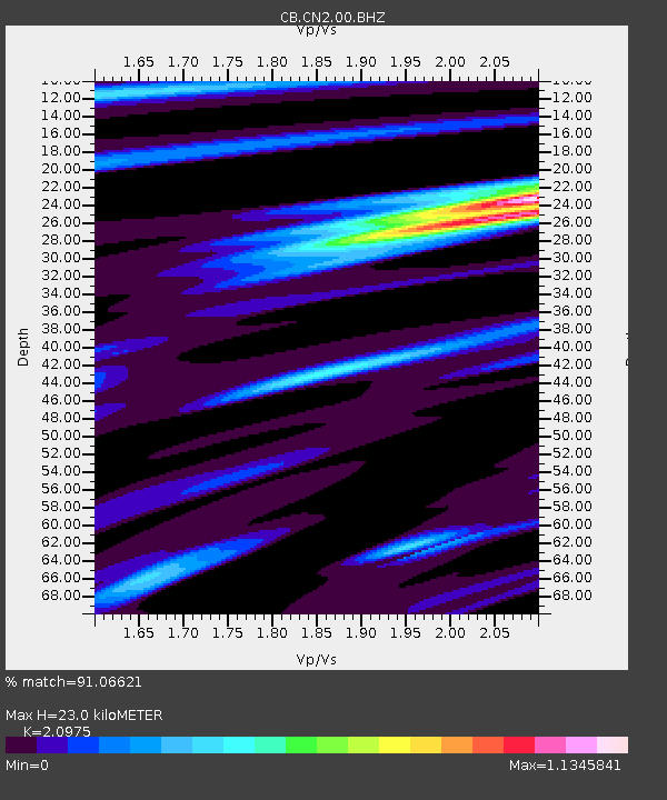
| Estimated Moho Depth: |
23.0 km |
| Estimated Crust Vp/Vs: |
2.10 |
| Assumed Crust Vp: |
6.459 km/s |
| Estimated Crust Vs: |
3.08 km/s |
| Estimated Crust Poisson's Ratio: |
0.35 |
|
| Radial Match: |
91.06621 % |
| Radial Bump: |
357 |
| Transverse Match: |
69.322975 % |
| Transverse Bump: |
400 |
| SOD ConfigId: |
469095 |
| Insert Time: |
2013-02-22 06:24:05.118 +0000 |
| GWidth: |
2.5 |
| Max Bumps: |
400 |
| Tol: |
0.001 |
|

Signal To Noise
| Channel | StoN | STA | LTA |
| CB:CN2:00:BHZ:20120812T10:53:15.240009Z | 8.277575 | 7.0103533E-7 | 8.469091E-8 |
| CB:CN2:00:BHN:20120812T10:53:15.240009Z | 1.7886494 | 1.0638838E-7 | 5.9479728E-8 |
| CB:CN2:00:BHE:20120812T10:53:15.240009Z | 6.6962605 | 4.0516048E-7 | 6.050548E-8 |
| Arrivals |
| Ps | 4.2 SECOND |
| PpPs | 10 SECOND |
| PsPs/PpSs | 14 SECOND |


