You are here: Home > Network List > G - GEOSCOPE Stations List
> Station TAM Tamanrasset, Algeria > Earthquake Result Viewer
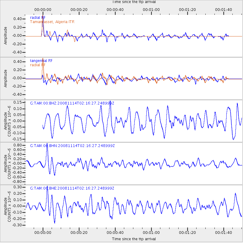
TAM Tamanrasset, Algeria - Earthquake Result Viewer
*The percent match for this event was below the threshold and hence no stack was calculated.
| Earthquake location: |
Bouvet Island Region |
| Earthquake latitude/longitude: |
-53.8/8.7 |
| Earthquake time(UTC): |
2008/11/14 (319) 02:05:09 GMT |
| Earthquake Depth: |
12 km |
| Earthquake Magnitude: |
5.7 MB, 5.5 MS, 5.9 MW, 5.9 MW |
| Earthquake Catalog/Contributor: |
WHDF/NEIC |
|
| Network: |
G GEOSCOPE |
| Station: |
TAM Tamanrasset, Algeria |
| Lat/Lon: |
22.79 N/5.53 E |
| Elevation: |
1377 m |
|
| Distance: |
76.3 deg |
| Az: |
356.961 deg |
| Baz: |
178.047 deg |
| Ray Param: |
$rayparam |
*The percent match for this event was below the threshold and hence was not used in the summary stack. |
|
| Radial Match: |
74.94688 % |
| Radial Bump: |
315 |
| Transverse Match: |
54.569813 % |
| Transverse Bump: |
400 |
| SOD ConfigId: |
2658 |
| Insert Time: |
2010-02-27 00:35:24.613 +0000 |
| GWidth: |
2.5 |
| Max Bumps: |
400 |
| Tol: |
0.001 |
|
Signal To Noise
| Channel | StoN | STA | LTA |
| G:TAM:00:BHN:20081114T02:16:27.248999Z | 4.53452 | 3.4387622E-7 | 7.5835196E-8 |
| G:TAM:00:BHE:20081114T02:16:27.248999Z | 3.3592217 | 1.269564E-7 | 3.7793395E-8 |
| G:TAM:00:BHZ:20081114T02:16:27.248999Z | 1.1470165 | 6.90734E-8 | 6.022006E-8 |
| Arrivals |
| Ps | |
| PpPs | |
| PsPs/PpSs | |


