You are here: Home > Network List > G - GEOSCOPE Stations List
> Station TAM Tamanrasset, Algeria > Earthquake Result Viewer
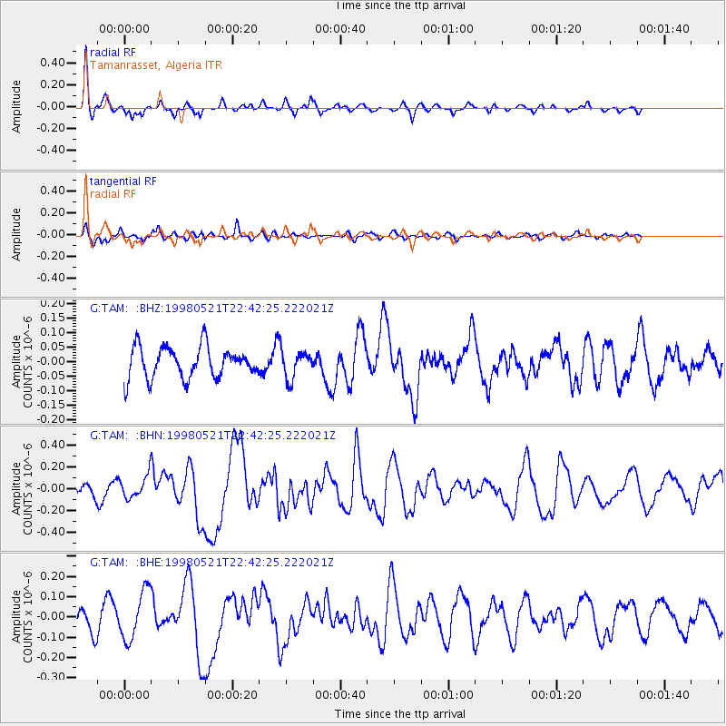
TAM Tamanrasset, Algeria - Earthquake Result Viewer
*The percent match for this event was below the threshold and hence no stack was calculated.
| Earthquake location: |
Prince Edward Islands Region |
| Earthquake latitude/longitude: |
-43.4/41.4 |
| Earthquake time(UTC): |
1998/05/21 (141) 22:31:22 GMT |
| Earthquake Depth: |
10 km |
| Earthquake Magnitude: |
5.8 MS, 5.4 MB, 6.3 UNKNOWN, 6.2 MW |
| Earthquake Catalog/Contributor: |
WHDF/NEIC |
|
| Network: |
G GEOSCOPE |
| Station: |
TAM Tamanrasset, Algeria |
| Lat/Lon: |
22.79 N/5.53 E |
| Elevation: |
1377 m |
|
| Distance: |
73.7 deg |
| Az: |
325.71 deg |
| Baz: |
153.579 deg |
| Ray Param: |
$rayparam |
*The percent match for this event was below the threshold and hence was not used in the summary stack. |
|
| Radial Match: |
81.228645 % |
| Radial Bump: |
341 |
| Transverse Match: |
61.572277 % |
| Transverse Bump: |
364 |
| SOD ConfigId: |
4480 |
| Insert Time: |
2010-02-27 00:35:36.696 +0000 |
| GWidth: |
2.5 |
| Max Bumps: |
400 |
| Tol: |
0.001 |
|
Signal To Noise
| Channel | StoN | STA | LTA |
| G:TAM: :BHN:19980521T22:42:25.222021Z | 1.4930507 | 1.0266854E-7 | 6.8764265E-8 |
| G:TAM: :BHE:19980521T22:42:25.222021Z | 2.3917372 | 1.2132789E-7 | 5.0727937E-8 |
| G:TAM: :BHZ:19980521T22:42:25.222021Z | 0.88175035 | 4.7479958E-8 | 5.384739E-8 |
| Arrivals |
| Ps | |
| PpPs | |
| PsPs/PpSs | |


