You are here: Home > Network List > UW - Pacific Northwest Regional Seismic Network Stations List
> Station MRBL Marblemount, WA, USA > Earthquake Result Viewer
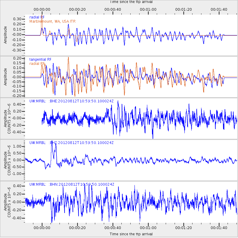
MRBL Marblemount, WA, USA - Earthquake Result Viewer
*The percent match for this event was below the threshold and hence no stack was calculated.
| Earthquake location: |
Xizang |
| Earthquake latitude/longitude: |
35.7/82.5 |
| Earthquake time(UTC): |
2012/08/12 (225) 10:47:06 GMT |
| Earthquake Depth: |
13 km |
| Earthquake Magnitude: |
6.1 MB, 6.1 MS, 6.2 MW, 6.3 MW |
| Earthquake Catalog/Contributor: |
WHDF/NEIC |
|
| Network: |
UW Pacific Northwest Regional Seismic Network |
| Station: |
MRBL Marblemount, WA, USA |
| Lat/Lon: |
48.52 N/121.48 W |
| Elevation: |
75 m |
|
| Distance: |
93.5 deg |
| Az: |
15.721 deg |
| Baz: |
340.618 deg |
| Ray Param: |
$rayparam |
*The percent match for this event was below the threshold and hence was not used in the summary stack. |
|
| Radial Match: |
69.58979 % |
| Radial Bump: |
400 |
| Transverse Match: |
57.604717 % |
| Transverse Bump: |
400 |
| SOD ConfigId: |
469095 |
| Insert Time: |
2013-02-22 06:31:08.408 +0000 |
| GWidth: |
2.5 |
| Max Bumps: |
400 |
| Tol: |
0.001 |
|
Signal To Noise
| Channel | StoN | STA | LTA |
| UW:MRBL: :BHZ:20120812T10:59:50.100024Z | 4.0919456 | 2.999818E-7 | 7.3310304E-8 |
| UW:MRBL: :BHN:20120812T10:59:50.100024Z | 1.3691525 | 1.0948418E-7 | 7.996493E-8 |
| UW:MRBL: :BHE:20120812T10:59:50.100024Z | 0.69871724 | 6.5607985E-8 | 9.389776E-8 |
| Arrivals |
| Ps | |
| PpPs | |
| PsPs/PpSs | |


