You are here: Home > Network List > UW - Pacific Northwest Regional Seismic Network Stations List
> Station UMAT Pilot Rock, OR, USA > Earthquake Result Viewer
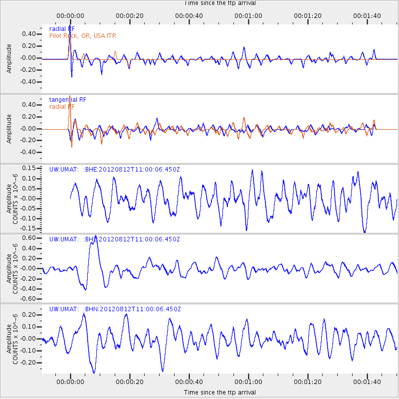
UMAT Pilot Rock, OR, USA - Earthquake Result Viewer
*The percent match for this event was below the threshold and hence no stack was calculated.
| Earthquake location: |
Xizang |
| Earthquake latitude/longitude: |
35.7/82.5 |
| Earthquake time(UTC): |
2012/08/12 (225) 10:47:06 GMT |
| Earthquake Depth: |
13 km |
| Earthquake Magnitude: |
6.1 MB, 6.1 MS, 6.2 MW, 6.3 MW |
| Earthquake Catalog/Contributor: |
WHDF/NEIC |
|
| Network: |
UW Pacific Northwest Regional Seismic Network |
| Station: |
UMAT Pilot Rock, OR, USA |
| Lat/Lon: |
45.29 N/118.96 W |
| Elevation: |
1318 m |
|
| Distance: |
97.1 deg |
| Az: |
15.097 deg |
| Baz: |
342.514 deg |
| Ray Param: |
$rayparam |
*The percent match for this event was below the threshold and hence was not used in the summary stack. |
|
| Radial Match: |
57.748642 % |
| Radial Bump: |
400 |
| Transverse Match: |
63.25484 % |
| Transverse Bump: |
400 |
| SOD ConfigId: |
469095 |
| Insert Time: |
2013-02-22 06:31:20.272 +0000 |
| GWidth: |
2.5 |
| Max Bumps: |
400 |
| Tol: |
0.001 |
|
Signal To Noise
| Channel | StoN | STA | LTA |
| UW:UMAT: :BHZ:20120812T11:00:06.450Z | 2.8707654 | 1.8550085E-7 | 6.461721E-8 |
| UW:UMAT: :BHN:20120812T11:00:06.450Z | 1.8478321 | 1.107066E-7 | 5.991161E-8 |
| UW:UMAT: :BHE:20120812T11:00:06.450Z | 1.005875 | 5.4518665E-8 | 5.4200243E-8 |
| Arrivals |
| Ps | |
| PpPs | |
| PsPs/PpSs | |


