You are here: Home > Network List > G - GEOSCOPE Stations List
> Station TAM Tamanrasset, Algeria > Earthquake Result Viewer
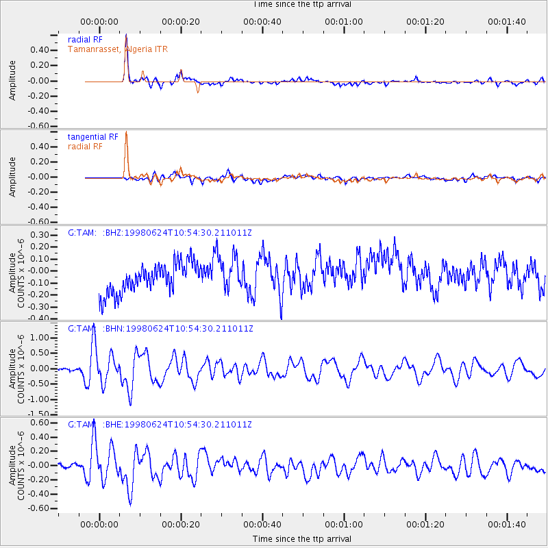
TAM Tamanrasset, Algeria - Earthquake Result Viewer
*The percent match for this event was below the threshold and hence no stack was calculated.
| Earthquake location: |
Southern Mid-Atlantic Ridge |
| Earthquake latitude/longitude: |
-37.3/-17.4 |
| Earthquake time(UTC): |
1998/06/24 (175) 10:44:30 GMT |
| Earthquake Depth: |
10 km |
| Earthquake Magnitude: |
5.7 MB, 5.8 MS, 6.0 UNKNOWN, 5.9 MW |
| Earthquake Catalog/Contributor: |
WHDF/NEIC |
|
| Network: |
G GEOSCOPE |
| Station: |
TAM Tamanrasset, Algeria |
| Lat/Lon: |
22.79 N/5.53 E |
| Elevation: |
1377 m |
|
| Distance: |
63.5 deg |
| Az: |
23.666 deg |
| Baz: |
200.296 deg |
| Ray Param: |
$rayparam |
*The percent match for this event was below the threshold and hence was not used in the summary stack. |
|
| Radial Match: |
87.24792 % |
| Radial Bump: |
400 |
| Transverse Match: |
43.24866 % |
| Transverse Bump: |
400 |
| SOD ConfigId: |
4480 |
| Insert Time: |
2010-02-27 00:35:38.653 +0000 |
| GWidth: |
2.5 |
| Max Bumps: |
400 |
| Tol: |
0.001 |
|
Signal To Noise
| Channel | StoN | STA | LTA |
| G:TAM: :BHN:19980624T10:54:30.211011Z | 8.939774 | 4.3666859E-7 | 4.8845596E-8 |
| G:TAM: :BHE:19980624T10:54:30.211011Z | 4.884718 | 2.20861E-7 | 4.521469E-8 |
| G:TAM: :BHZ:19980624T10:54:30.211011Z | 1.1756017 | 1.4153315E-7 | 1.2039209E-7 |
| Arrivals |
| Ps | |
| PpPs | |
| PsPs/PpSs | |


