You are here: Home > Network List > G - GEOSCOPE Stations List
> Station TAM Tamanrasset, Algeria > Earthquake Result Viewer
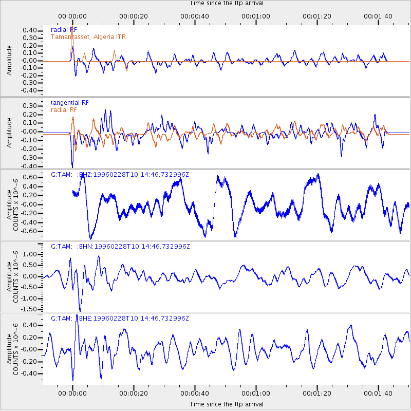
TAM Tamanrasset, Algeria - Earthquake Result Viewer
*The percent match for this event was below the threshold and hence no stack was calculated.
| Earthquake location: |
Prince Edward Islands Region |
| Earthquake latitude/longitude: |
-51.8/40.3 |
| Earthquake time(UTC): |
1996/02/28 (059) 10:03:07 GMT |
| Earthquake Depth: |
10 km |
| Earthquake Magnitude: |
5.5 MB, 5.4 MS |
| Earthquake Catalog/Contributor: |
WHDF/NEIC |
|
| Network: |
G GEOSCOPE |
| Station: |
TAM Tamanrasset, Algeria |
| Lat/Lon: |
22.79 N/5.53 E |
| Elevation: |
1377 m |
|
| Distance: |
80.3 deg |
| Az: |
327.681 deg |
| Baz: |
158.915 deg |
| Ray Param: |
$rayparam |
*The percent match for this event was below the threshold and hence was not used in the summary stack. |
|
| Radial Match: |
53.034122 % |
| Radial Bump: |
400 |
| Transverse Match: |
58.352478 % |
| Transverse Bump: |
400 |
| SOD ConfigId: |
4480 |
| Insert Time: |
2010-02-27 00:35:39.718 +0000 |
| GWidth: |
2.5 |
| Max Bumps: |
400 |
| Tol: |
0.001 |
|
Signal To Noise
| Channel | StoN | STA | LTA |
| G:TAM: :BHN:19960228T10:14:46.732996Z | 2.5802276 | 6.947657E-7 | 2.6926526E-7 |
| G:TAM: :BHE:19960228T10:14:46.732996Z | 1.5438468 | 2.676494E-7 | 1.7336525E-7 |
| G:TAM: :BHZ:19960228T10:14:46.732996Z | 1.135203 | 3.4388847E-7 | 3.0293126E-7 |
| Arrivals |
| Ps | |
| PpPs | |
| PsPs/PpSs | |


