You are here: Home > Network List > TA - USArray Transportable Network (new EarthScope stations) Stations List
> Station X43A Marvell, AR, USA > Earthquake Result Viewer
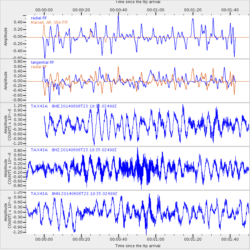
X43A Marvell, AR, USA - Earthquake Result Viewer
*The percent match for this event was below the threshold and hence no stack was calculated.
| Earthquake location: |
Samoa Islands Region |
| Earthquake latitude/longitude: |
-14.9/-174.9 |
| Earthquake time(UTC): |
2014/06/06 (157) 23:06:50 GMT |
| Earthquake Depth: |
10 km |
| Earthquake Magnitude: |
5.5 MW |
| Earthquake Catalog/Contributor: |
ISC/ISC |
|
| Network: |
TA USArray Transportable Network (new EarthScope stations) |
| Station: |
X43A Marvell, AR, USA |
| Lat/Lon: |
34.52 N/90.88 W |
| Elevation: |
53 m |
|
| Distance: |
93.5 deg |
| Az: |
55.372 deg |
| Baz: |
254.425 deg |
| Ray Param: |
$rayparam |
*The percent match for this event was below the threshold and hence was not used in the summary stack. |
|
| Radial Match: |
46.536076 % |
| Radial Bump: |
400 |
| Transverse Match: |
45.728004 % |
| Transverse Bump: |
400 |
| SOD ConfigId: |
3390531 |
| Insert Time: |
2019-04-12 04:44:22.910 +0000 |
| GWidth: |
2.5 |
| Max Bumps: |
400 |
| Tol: |
0.001 |
|
Signal To Noise
| Channel | StoN | STA | LTA |
| TA:X43A: :BHZ:20140606T23:19:35.02499Z | 0.81007653 | 1.6360694E-7 | 2.019648E-7 |
| TA:X43A: :BHN:20140606T23:19:35.02499Z | 1.4598581 | 4.036032E-7 | 2.7646743E-7 |
| TA:X43A: :BHE:20140606T23:19:35.02499Z | 2.0064466 | 7.046171E-7 | 3.511766E-7 |
| Arrivals |
| Ps | |
| PpPs | |
| PsPs/PpSs | |


