You are here: Home > Network List > G - GEOSCOPE Stations List
> Station TAM Tamanrasset, Algeria > Earthquake Result Viewer
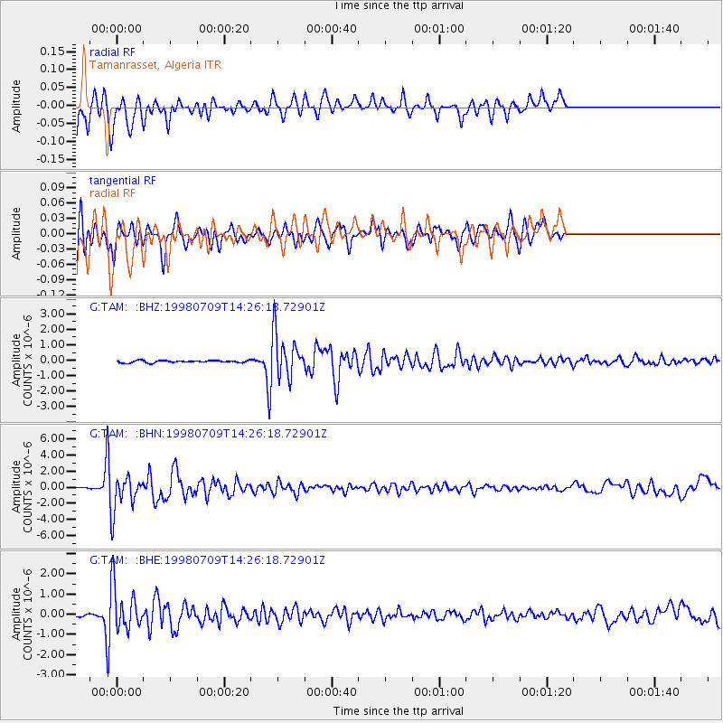
TAM Tamanrasset, Algeria - Earthquake Result Viewer
*The percent match for this event was below the threshold and hence no stack was calculated.
| Earthquake location: |
Armenia-Azerbaijan-Iran Bord Reg |
| Earthquake latitude/longitude: |
38.7/48.5 |
| Earthquake time(UTC): |
1998/07/09 (190) 14:19:18 GMT |
| Earthquake Depth: |
26 km |
| Earthquake Magnitude: |
5.9 MB, 6.0 UNKNOWN, 5.7 ME |
| Earthquake Catalog/Contributor: |
WHDF/NEIC |
|
| Network: |
G GEOSCOPE |
| Station: |
TAM Tamanrasset, Algeria |
| Lat/Lon: |
22.79 N/5.53 E |
| Elevation: |
1377 m |
|
| Distance: |
39.8 deg |
| Az: |
259.267 deg |
| Baz: |
56.394 deg |
| Ray Param: |
$rayparam |
*The percent match for this event was below the threshold and hence was not used in the summary stack. |
|
| Radial Match: |
96.39295 % |
| Radial Bump: |
235 |
| Transverse Match: |
82.55318 % |
| Transverse Bump: |
400 |
| SOD ConfigId: |
4480 |
| Insert Time: |
2010-02-27 00:35:42.247 +0000 |
| GWidth: |
2.5 |
| Max Bumps: |
400 |
| Tol: |
0.001 |
|
Signal To Noise
| Channel | StoN | STA | LTA |
| G:TAM: :BHN:19980709T14:26:18.72901Z | 21.089954 | 2.1044461E-6 | 9.9784295E-8 |
| G:TAM: :BHE:19980709T14:26:18.72901Z | 22.008192 | 1.0649904E-6 | 4.839064E-8 |
| G:TAM: :BHZ:19980709T14:26:18.72901Z | 20.19712 | 1.4315638E-6 | 7.08796E-8 |
| Arrivals |
| Ps | |
| PpPs | |
| PsPs/PpSs | |


