You are here: Home > Network List > CI - Caltech Regional Seismic Network Stations List
> Station SVD Seven Oaks Dam, California, USA > Earthquake Result Viewer
SVD Seven Oaks Dam, California, USA - Earthquake Result Viewer
| Earthquake location: |
Sea Of Okhotsk |
| Earthquake latitude/longitude: |
49.8/145.1 |
| Earthquake time(UTC): |
2012/08/14 (227) 02:59:38 GMT |
| Earthquake Depth: |
583 km |
| Earthquake Magnitude: |
6.9 MB, 7.7 MW, 7.7 MW |
| Earthquake Catalog/Contributor: |
WHDF/NEIC |
|
| Network: |
CI Caltech Regional Seismic Network |
| Station: |
SVD Seven Oaks Dam, California, USA |
| Lat/Lon: |
34.11 N/117.10 W |
| Elevation: |
574 m |
|
| Distance: |
69.4 deg |
| Az: |
61.417 deg |
| Baz: |
316.704 deg |
| Ray Param: |
0.053629205 |
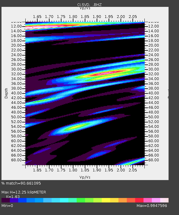
| Estimated Moho Depth: |
12.25 km |
| Estimated Crust Vp/Vs: |
1.63 |
| Assumed Crust Vp: |
6.276 km/s |
| Estimated Crust Vs: |
3.85 km/s |
| Estimated Crust Poisson's Ratio: |
0.20 |
|
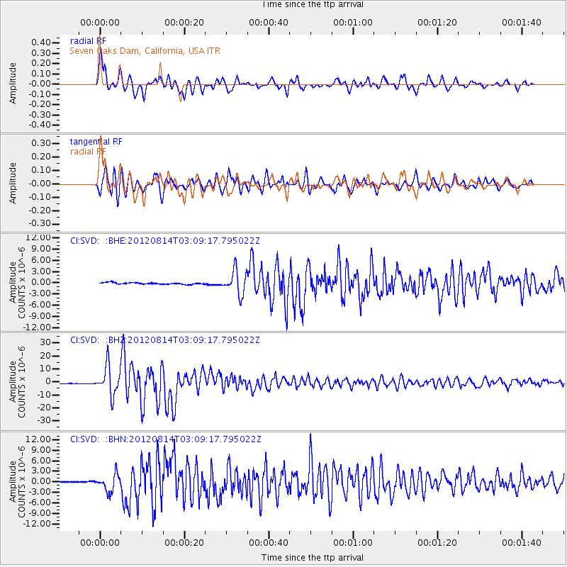
| Radial Match: |
90.661095 % |
| Radial Bump: |
400 |
| Transverse Match: |
91.44471 % |
| Transverse Bump: |
400 |
| SOD ConfigId: |
469095 |
| Insert Time: |
2013-02-22 06:37:54.755 +0000 |
| GWidth: |
2.5 |
| Max Bumps: |
400 |
| Tol: |
0.001 |
|
Signal To Noise
| Channel | StoN | STA | LTA |
| CI:SVD: :BHZ:20120814T03:09:17.795022Z | 56.72741 | 1.1451824E-5 | 2.0187463E-7 |
| CI:SVD: :BHN:20120814T03:09:17.795022Z | 20.997454 | 2.4677754E-6 | 1.17527364E-7 |
| CI:SVD: :BHE:20120814T03:09:17.795022Z | 14.99716 | 3.2621224E-6 | 2.1751602E-7 |
| Arrivals |
| Ps | 1.3 SECOND |
| PpPs | 5.0 SECOND |
| PsPs/PpSs | 6.2 SECOND |


