You are here: Home > Network List > CI - Caltech Regional Seismic Network Stations List
> Station SWS Sam W. Stewart, Westmorland, CA, USA > Earthquake Result Viewer
SWS Sam W. Stewart, Westmorland, CA, USA - Earthquake Result Viewer

| Earthquake location: |
Sea Of Okhotsk |
| Earthquake latitude/longitude: |
49.8/145.1 |
| Earthquake time(UTC): |
2012/08/14 (227) 02:59:38 GMT |
| Earthquake Depth: |
583 km |
| Earthquake Magnitude: |
6.9 MB, 7.7 MW, 7.7 MW |
| Earthquake Catalog/Contributor: |
WHDF/NEIC |
|
| Network: |
CI Caltech Regional Seismic Network |
| Station: |
SWS Sam W. Stewart, Westmorland, CA, USA |
| Lat/Lon: |
32.94 N/115.80 W |
| Elevation: |
140 m |
|
| Distance: |
71.0 deg |
| Az: |
61.412 deg |
| Baz: |
317.418 deg |
| Ray Param: |
0.052627623 |
| Estimated Moho Depth: |
16.25 km |
| Estimated Crust Vp/Vs: |
1.99 |
| Assumed Crust Vp: |
6.155 km/s |
| Estimated Crust Vs: |
3.089 km/s |
| Estimated Crust Poisson's Ratio: |
0.33 |
|
| Radial Match: |
92.06079 % |
| Radial Bump: |
400 |
| Transverse Match: |
88.56961 % |
| Transverse Bump: |
400 |
| SOD ConfigId: |
469095 |
| Insert Time: |
2013-02-22 06:39:08.868 +0000 |
| GWidth: |
2.5 |
| Max Bumps: |
400 |
| Tol: |
0.001 |
|
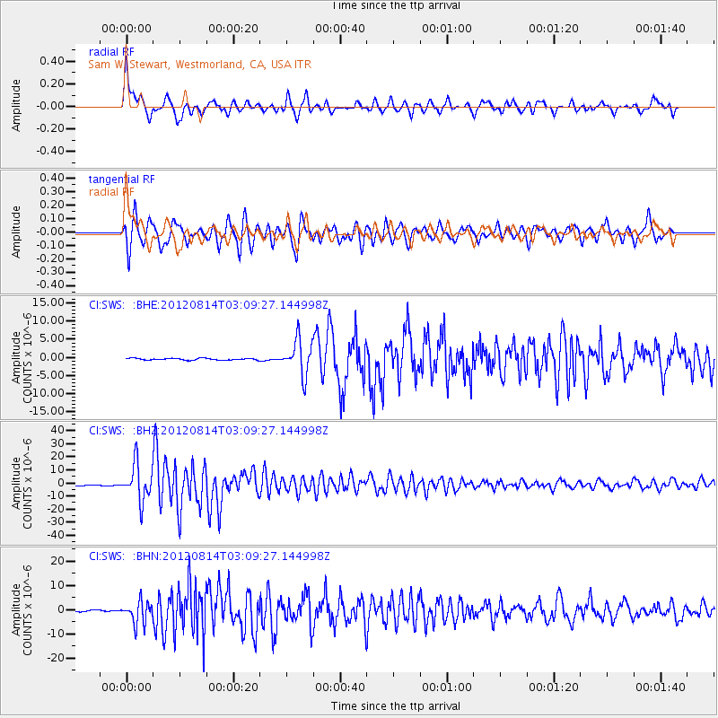
Signal To Noise
| Channel | StoN | STA | LTA |
| CI:SWS: :BHZ:20120814T03:09:27.144998Z | 68.45862 | 1.3924268E-5 | 2.0339687E-7 |
| CI:SWS: :BHN:20120814T03:09:27.144998Z | 15.014062 | 4.6109744E-6 | 3.0711038E-7 |
| CI:SWS: :BHE:20120814T03:09:27.144998Z | 20.520006 | 4.852419E-6 | 2.3647259E-7 |
| Arrivals |
| Ps | 2.7 SECOND |
| PpPs | 7.7 SECOND |
| PsPs/PpSs | 10 SECOND |


