You are here: Home > Network List > IW - Intermountain West Stations List
> Station FXWY Fox Creek, Wyoming, USA > Earthquake Result Viewer
FXWY Fox Creek, Wyoming, USA - Earthquake Result Viewer

| Earthquake location: |
Sea Of Okhotsk |
| Earthquake latitude/longitude: |
49.8/145.1 |
| Earthquake time(UTC): |
2012/08/14 (227) 02:59:38 GMT |
| Earthquake Depth: |
583 km |
| Earthquake Magnitude: |
6.9 MB, 7.7 MW, 7.7 MW |
| Earthquake Catalog/Contributor: |
WHDF/NEIC |
|
| Network: |
IW Intermountain West |
| Station: |
FXWY Fox Creek, Wyoming, USA |
| Lat/Lon: |
43.64 N/111.03 W |
| Elevation: |
2254 m |
|
| Distance: |
65.8 deg |
| Az: |
50.617 deg |
| Baz: |
316.382 deg |
| Ray Param: |
0.055924956 |
| Estimated Moho Depth: |
37.5 km |
| Estimated Crust Vp/Vs: |
1.85 |
| Assumed Crust Vp: |
6.207 km/s |
| Estimated Crust Vs: |
3.364 km/s |
| Estimated Crust Poisson's Ratio: |
0.29 |
|
| Radial Match: |
90.38753 % |
| Radial Bump: |
400 |
| Transverse Match: |
88.566086 % |
| Transverse Bump: |
400 |
| SOD ConfigId: |
469095 |
| Insert Time: |
2013-02-22 06:43:54.205 +0000 |
| GWidth: |
2.5 |
| Max Bumps: |
400 |
| Tol: |
0.001 |
|
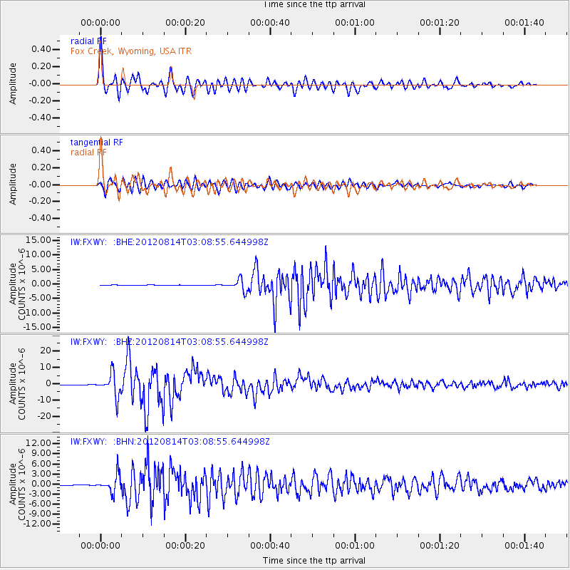
Signal To Noise
| Channel | StoN | STA | LTA |
| IW:FXWY: :BHZ:20120814T03:08:55.644998Z | 121.28458 | 7.0481074E-6 | 5.8112153E-8 |
| IW:FXWY: :BHN:20120814T03:08:55.644998Z | 47.254658 | 2.6776886E-6 | 5.6665076E-8 |
| IW:FXWY: :BHE:20120814T03:08:55.644998Z | 49.815365 | 1.9874376E-6 | 3.9896072E-8 |
| Arrivals |
| Ps | 5.3 SECOND |
| PpPs | 17 SECOND |
| PsPs/PpSs | 22 SECOND |


