You are here: Home > Network List > TA - USArray Transportable Network (new EarthScope stations) Stations List
> Station I05D Terrebonne, OR, USA > Earthquake Result Viewer
I05D Terrebonne, OR, USA - Earthquake Result Viewer
| Earthquake location: |
Sea Of Okhotsk |
| Earthquake latitude/longitude: |
49.8/145.1 |
| Earthquake time(UTC): |
2012/08/14 (227) 02:59:38 GMT |
| Earthquake Depth: |
583 km |
| Earthquake Magnitude: |
6.9 MB, 7.7 MW, 7.7 MW |
| Earthquake Catalog/Contributor: |
WHDF/NEIC |
|
| Network: |
TA USArray Transportable Network (new EarthScope stations) |
| Station: |
I05D Terrebonne, OR, USA |
| Lat/Lon: |
44.34 N/121.34 W |
| Elevation: |
1546 m |
|
| Distance: |
59.9 deg |
| Az: |
55.86 deg |
| Baz: |
311.633 deg |
| Ray Param: |
0.059547335 |
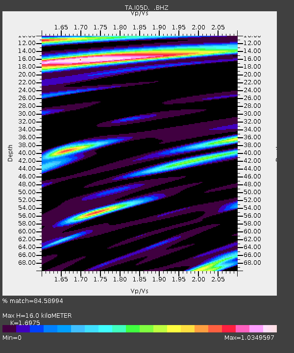
| Estimated Moho Depth: |
16.0 km |
| Estimated Crust Vp/Vs: |
1.70 |
| Assumed Crust Vp: |
6.597 km/s |
| Estimated Crust Vs: |
3.887 km/s |
| Estimated Crust Poisson's Ratio: |
0.23 |
|
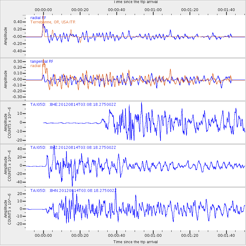
| Radial Match: |
84.58994 % |
| Radial Bump: |
400 |
| Transverse Match: |
71.74388 % |
| Transverse Bump: |
400 |
| SOD ConfigId: |
469095 |
| Insert Time: |
2013-02-22 06:48:07.082 +0000 |
| GWidth: |
2.5 |
| Max Bumps: |
400 |
| Tol: |
0.001 |
|
Signal To Noise
| Channel | StoN | STA | LTA |
| TA:I05D: :BHZ:20120814T03:08:18.275002Z | 48.65007 | 1.2023169E-5 | 2.471357E-7 |
| TA:I05D: :BHN:20120814T03:08:18.275002Z | 8.857842 | 1.9250385E-6 | 2.173259E-7 |
| TA:I05D: :BHE:20120814T03:08:18.275002Z | 10.464253 | 2.4271762E-6 | 2.319493E-7 |
| Arrivals |
| Ps | 1.8 SECOND |
| PpPs | 6.2 SECOND |
| PsPs/PpSs | 8.0 SECOND |


