You are here: Home > Network List > TA - USArray Transportable Network (new EarthScope stations) Stations List
> Station 240A Hunter Patterson, Mansfield, LA, USA > Earthquake Result Viewer
240A Hunter Patterson, Mansfield, LA, USA - Earthquake Result Viewer

| Earthquake location: |
Sea Of Okhotsk |
| Earthquake latitude/longitude: |
49.8/145.1 |
| Earthquake time(UTC): |
2012/08/14 (227) 02:59:38 GMT |
| Earthquake Depth: |
583 km |
| Earthquake Magnitude: |
6.9 MB, 7.7 MW, 7.7 MW |
| Earthquake Catalog/Contributor: |
WHDF/NEIC |
|
| Network: |
TA USArray Transportable Network (new EarthScope stations) |
| Station: |
240A Hunter Patterson, Mansfield, LA, USA |
| Lat/Lon: |
32.04 N/93.76 W |
| Elevation: |
119 m |
|
| Distance: |
83.3 deg |
| Az: |
47.029 deg |
| Baz: |
326.064 deg |
| Ray Param: |
0.04457472 |
| Estimated Moho Depth: |
11.5 km |
| Estimated Crust Vp/Vs: |
1.91 |
| Assumed Crust Vp: |
6.245 km/s |
| Estimated Crust Vs: |
3.27 km/s |
| Estimated Crust Poisson's Ratio: |
0.31 |
|
| Radial Match: |
97.64177 % |
| Radial Bump: |
400 |
| Transverse Match: |
94.969696 % |
| Transverse Bump: |
400 |
| SOD ConfigId: |
469095 |
| Insert Time: |
2013-02-22 06:50:55.943 +0000 |
| GWidth: |
2.5 |
| Max Bumps: |
400 |
| Tol: |
0.001 |
|
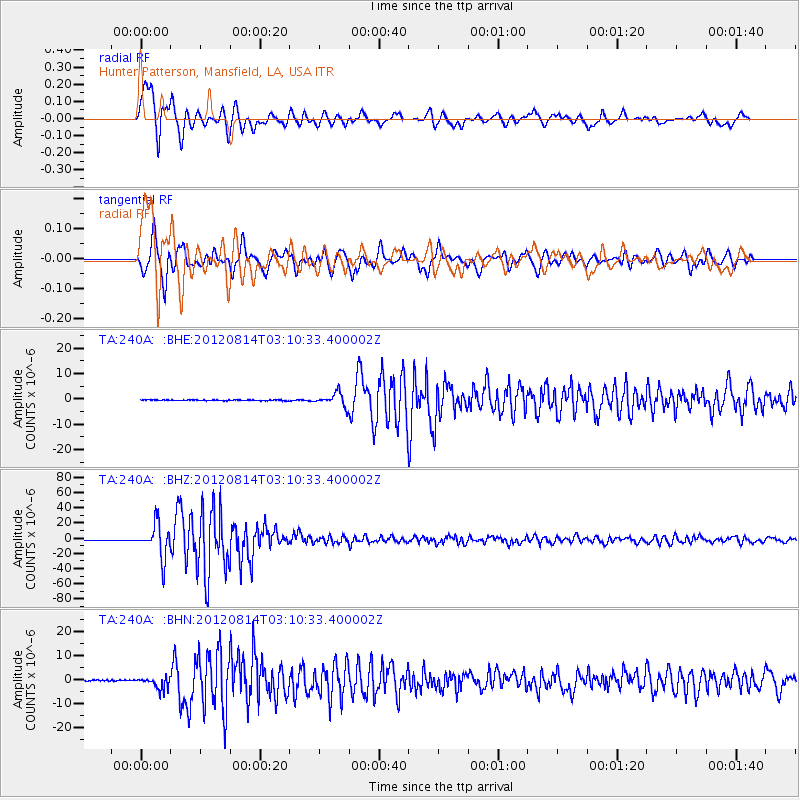
Signal To Noise
| Channel | StoN | STA | LTA |
| TA:240A: :BHZ:20120814T03:10:33.400002Z | 95.27025 | 2.1759439E-5 | 2.28397E-7 |
| TA:240A: :BHN:20120814T03:10:33.400002Z | 11.027086 | 2.48713E-6 | 2.2554734E-7 |
| TA:240A: :BHE:20120814T03:10:33.400002Z | 16.662052 | 2.5899683E-6 | 1.5544114E-7 |
| Arrivals |
| Ps | 1.7 SECOND |
| PpPs | 5.2 SECOND |
| PsPs/PpSs | 7.0 SECOND |


