You are here: Home > Network List > TA - USArray Transportable Network (new EarthScope stations) Stations List
> Station 140A Cam and Jess, Hughton, LA, USA > Earthquake Result Viewer
140A Cam and Jess, Hughton, LA, USA - Earthquake Result Viewer
| Earthquake location: |
Sea Of Okhotsk |
| Earthquake latitude/longitude: |
49.8/145.1 |
| Earthquake time(UTC): |
2012/08/14 (227) 02:59:38 GMT |
| Earthquake Depth: |
583 km |
| Earthquake Magnitude: |
6.9 MB, 7.7 MW, 7.7 MW |
| Earthquake Catalog/Contributor: |
WHDF/NEIC |
|
| Network: |
TA USArray Transportable Network (new EarthScope stations) |
| Station: |
140A Cam and Jess, Hughton, LA, USA |
| Lat/Lon: |
32.64 N/93.57 W |
| Elevation: |
56 m |
|
| Distance: |
82.9 deg |
| Az: |
46.558 deg |
| Baz: |
326.107 deg |
| Ray Param: |
0.04485488 |
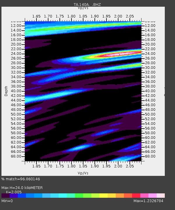
| Estimated Moho Depth: |
24.0 km |
| Estimated Crust Vp/Vs: |
2.01 |
| Assumed Crust Vp: |
6.245 km/s |
| Estimated Crust Vs: |
3.115 km/s |
| Estimated Crust Poisson's Ratio: |
0.33 |
|
| Radial Match: |
96.860146 % |
| Radial Bump: |
400 |
| Transverse Match: |
92.00314 % |
| Transverse Bump: |
400 |
| SOD ConfigId: |
469095 |
| Insert Time: |
2013-02-22 06:51:08.416 +0000 |
| GWidth: |
2.5 |
| Max Bumps: |
400 |
| Tol: |
0.001 |
|

Signal To Noise
| Channel | StoN | STA | LTA |
| TA:140A: :BHZ:20120814T03:10:31.350015Z | 124.18171 | 1.8705055E-5 | 1.5062649E-7 |
| TA:140A: :BHN:20120814T03:10:31.350015Z | 21.140663 | 3.2772648E-6 | 1.5502185E-7 |
| TA:140A: :BHE:20120814T03:10:31.350015Z | 15.369906 | 2.8697907E-6 | 1.8671491E-7 |
| Arrivals |
| Ps | 3.9 SECOND |
| PpPs | 11 SECOND |
| PsPs/PpSs | 15 SECOND |


