You are here: Home > Network List > UO - University of Oregon Regional Network Stations List
> Station DBO Dodson Butte, OR (UO CREST BB SMO) > Earthquake Result Viewer
DBO Dodson Butte, OR (UO CREST BB SMO) - Earthquake Result Viewer
| Earthquake location: |
Sea Of Okhotsk |
| Earthquake latitude/longitude: |
49.8/145.1 |
| Earthquake time(UTC): |
2012/08/14 (227) 02:59:38 GMT |
| Earthquake Depth: |
583 km |
| Earthquake Magnitude: |
6.9 MB, 7.7 MW, 7.7 MW |
| Earthquake Catalog/Contributor: |
WHDF/NEIC |
|
| Network: |
UO University of Oregon Regional Network |
| Station: |
DBO Dodson Butte, OR (UO CREST BB SMO) |
| Lat/Lon: |
43.12 N/123.24 W |
| Elevation: |
984 m |
|
| Distance: |
59.7 deg |
| Az: |
57.975 deg |
| Baz: |
311.385 deg |
| Ray Param: |
0.059685696 |
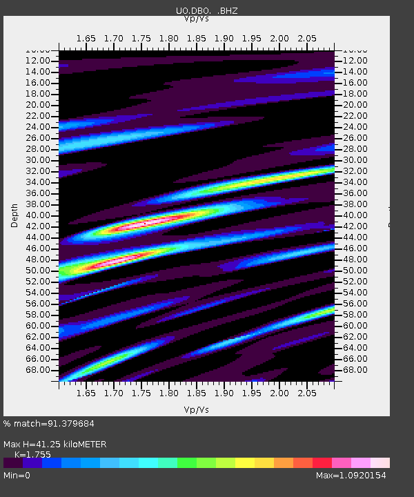
| Estimated Moho Depth: |
41.25 km |
| Estimated Crust Vp/Vs: |
1.75 |
| Assumed Crust Vp: |
6.522 km/s |
| Estimated Crust Vs: |
3.716 km/s |
| Estimated Crust Poisson's Ratio: |
0.26 |
|
| Radial Match: |
91.379684 % |
| Radial Bump: |
400 |
| Transverse Match: |
81.7262 % |
| Transverse Bump: |
400 |
| SOD ConfigId: |
469095 |
| Insert Time: |
2013-02-22 06:53:04.222 +0000 |
| GWidth: |
2.5 |
| Max Bumps: |
400 |
| Tol: |
0.001 |
|

Signal To Noise
| Channel | StoN | STA | LTA |
| UO:DBO: :BHZ:20120814T03:08:16.790017Z | 45.499886 | 1.2371607E-5 | 2.7190416E-7 |
| UO:DBO: :BHN:20120814T03:08:16.790017Z | 29.016207 | 5.603785E-6 | 1.9312604E-7 |
| UO:DBO: :BHE:20120814T03:08:16.790017Z | 20.593517 | 5.1351876E-6 | 2.4935943E-7 |
| Arrivals |
| Ps | 5.0 SECOND |
| PpPs | 17 SECOND |
| PsPs/PpSs | 22 SECOND |


