You are here: Home > Network List > UW - Pacific Northwest Regional Seismic Network Stations List
> Station LON Longmire (broad-band and DWWSSN) > Earthquake Result Viewer
LON Longmire (broad-band and DWWSSN) - Earthquake Result Viewer
| Earthquake location: |
Sea Of Okhotsk |
| Earthquake latitude/longitude: |
49.8/145.1 |
| Earthquake time(UTC): |
2012/08/14 (227) 02:59:38 GMT |
| Earthquake Depth: |
583 km |
| Earthquake Magnitude: |
6.9 MB, 7.7 MW, 7.7 MW |
| Earthquake Catalog/Contributor: |
WHDF/NEIC |
|
| Network: |
UW Pacific Northwest Regional Seismic Network |
| Station: |
LON Longmire (broad-band and DWWSSN) |
| Lat/Lon: |
46.75 N/121.81 W |
| Elevation: |
850 m |
|
| Distance: |
58.1 deg |
| Az: |
53.989 deg |
| Baz: |
310.335 deg |
| Ray Param: |
0.060673445 |
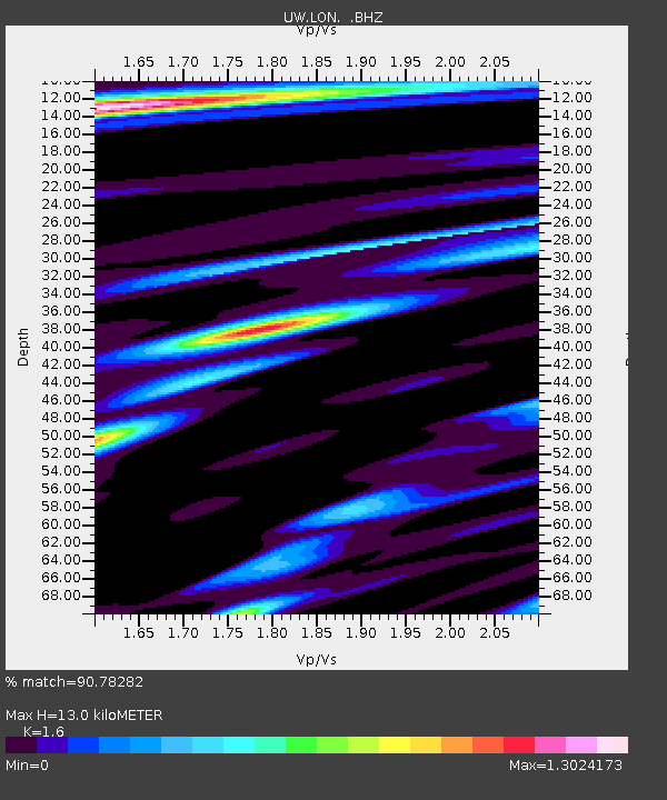
| Estimated Moho Depth: |
13.0 km |
| Estimated Crust Vp/Vs: |
1.60 |
| Assumed Crust Vp: |
6.597 km/s |
| Estimated Crust Vs: |
4.123 km/s |
| Estimated Crust Poisson's Ratio: |
0.18 |
|
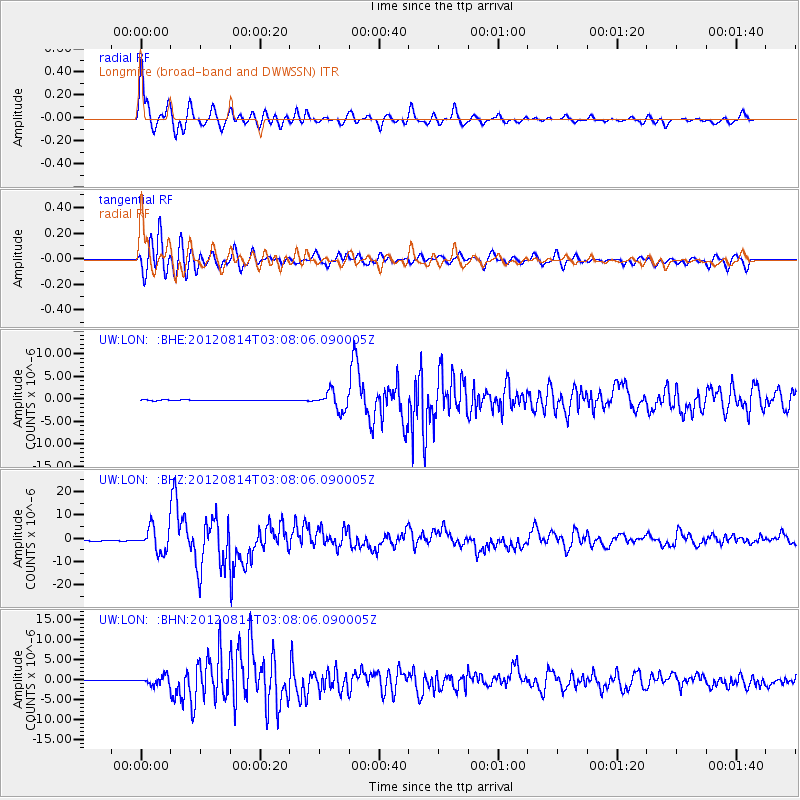
| Radial Match: |
90.78282 % |
| Radial Bump: |
396 |
| Transverse Match: |
78.96864 % |
| Transverse Bump: |
400 |
| SOD ConfigId: |
469095 |
| Insert Time: |
2013-02-22 06:53:28.639 +0000 |
| GWidth: |
2.5 |
| Max Bumps: |
400 |
| Tol: |
0.001 |
|
Signal To Noise
| Channel | StoN | STA | LTA |
| UW:LON: :BHZ:20120814T03:08:06.090005Z | 49.55843 | 5.2413925E-6 | 1.0576188E-7 |
| UW:LON: :BHN:20120814T03:08:06.090005Z | 15.327384 | 1.0561643E-6 | 6.890701E-8 |
| UW:LON: :BHE:20120814T03:08:06.090005Z | 25.889168 | 2.0386685E-6 | 7.8746E-8 |
| Arrivals |
| Ps | 1.2 SECOND |
| PpPs | 4.9 SECOND |
| PsPs/PpSs | 6.1 SECOND |


