You are here: Home > Network List > UW - Pacific Northwest Regional Seismic Network Stations List
> Station UMAT Pilot Rock, OR, USA > Earthquake Result Viewer
UMAT Pilot Rock, OR, USA - Earthquake Result Viewer
| Earthquake location: |
Sea Of Okhotsk |
| Earthquake latitude/longitude: |
49.8/145.1 |
| Earthquake time(UTC): |
2012/08/14 (227) 02:59:38 GMT |
| Earthquake Depth: |
583 km |
| Earthquake Magnitude: |
6.9 MB, 7.7 MW, 7.7 MW |
| Earthquake Catalog/Contributor: |
WHDF/NEIC |
|
| Network: |
UW Pacific Northwest Regional Seismic Network |
| Station: |
UMAT Pilot Rock, OR, USA |
| Lat/Lon: |
45.29 N/118.96 W |
| Elevation: |
1318 m |
|
| Distance: |
60.5 deg |
| Az: |
53.74 deg |
| Baz: |
312.252 deg |
| Ray Param: |
0.059159413 |
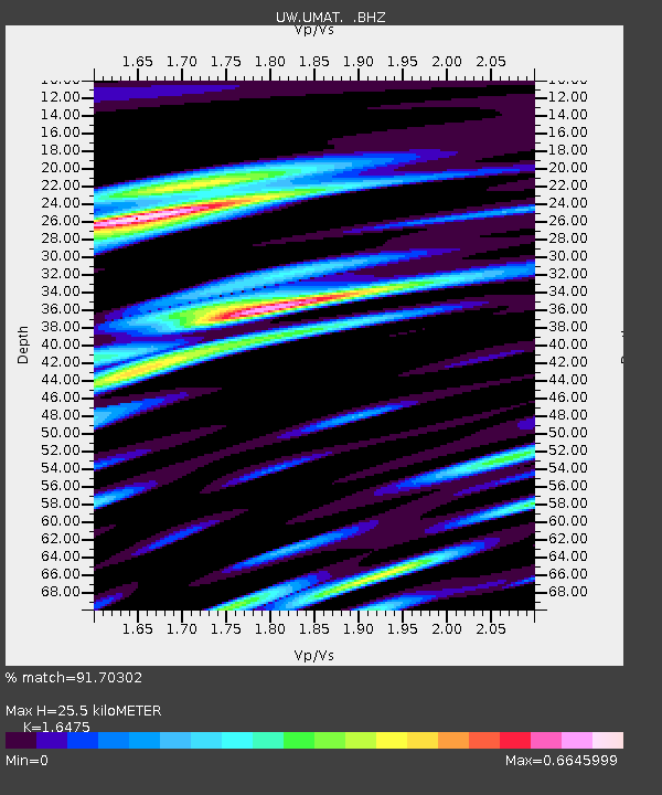
| Estimated Moho Depth: |
25.5 km |
| Estimated Crust Vp/Vs: |
1.65 |
| Assumed Crust Vp: |
6.571 km/s |
| Estimated Crust Vs: |
3.988 km/s |
| Estimated Crust Poisson's Ratio: |
0.21 |
|
| Radial Match: |
91.70302 % |
| Radial Bump: |
400 |
| Transverse Match: |
73.42159 % |
| Transverse Bump: |
400 |
| SOD ConfigId: |
469095 |
| Insert Time: |
2013-02-22 06:54:45.789 +0000 |
| GWidth: |
2.5 |
| Max Bumps: |
400 |
| Tol: |
0.001 |
|

Signal To Noise
| Channel | StoN | STA | LTA |
| UW:UMAT: :BHZ:20120814T03:08:22.400002Z | 71.048744 | 6.0972975E-6 | 8.581851E-8 |
| UW:UMAT: :BHN:20120814T03:08:22.400002Z | 32.990273 | 2.3538998E-6 | 7.135133E-8 |
| UW:UMAT: :BHE:20120814T03:08:22.400002Z | 32.027626 | 2.6030634E-6 | 8.1275566E-8 |
| Arrivals |
| Ps | 2.6 SECOND |
| PpPs | 9.8 SECOND |
| PsPs/PpSs | 12 SECOND |


