You are here: Home > Network List > G - GEOSCOPE Stations List
> Station TAM Tamanrasset, Algeria > Earthquake Result Viewer
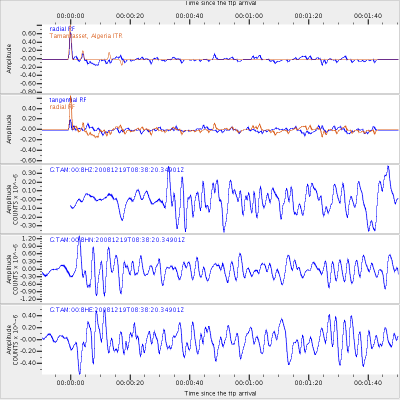
TAM Tamanrasset, Algeria - Earthquake Result Viewer
*The percent match for this event was below the threshold and hence no stack was calculated.
| Earthquake location: |
Northern Mid-Atlantic Ridge |
| Earthquake latitude/longitude: |
47.0/-27.3 |
| Earthquake time(UTC): |
2008/12/19 (354) 08:31:51 GMT |
| Earthquake Depth: |
2.0 km |
| Earthquake Magnitude: |
5.8 MB, 5.6 MS, 5.9 MW, 5.8 MW |
| Earthquake Catalog/Contributor: |
WHDF/NEIC |
|
| Network: |
G GEOSCOPE |
| Station: |
TAM Tamanrasset, Algeria |
| Lat/Lon: |
22.79 N/5.53 E |
| Elevation: |
1377 m |
|
| Distance: |
35.7 deg |
| Az: |
121.112 deg |
| Baz: |
320.582 deg |
| Ray Param: |
$rayparam |
*The percent match for this event was below the threshold and hence was not used in the summary stack. |
|
| Radial Match: |
77.19383 % |
| Radial Bump: |
371 |
| Transverse Match: |
66.50734 % |
| Transverse Bump: |
400 |
| SOD ConfigId: |
2658 |
| Insert Time: |
2010-02-27 00:36:02.494 +0000 |
| GWidth: |
2.5 |
| Max Bumps: |
400 |
| Tol: |
0.001 |
|
Signal To Noise
| Channel | StoN | STA | LTA |
| G:TAM:00:BHN:20081219T08:38:20.34901Z | 4.525569 | 5.31958E-7 | 1.1754499E-7 |
| G:TAM:00:BHE:20081219T08:38:20.34901Z | 2.978086 | 2.3900418E-7 | 8.0254296E-8 |
| G:TAM:00:BHZ:20081219T08:38:20.34901Z | 2.015209 | 1.3976248E-7 | 6.935384E-8 |
| Arrivals |
| Ps | |
| PpPs | |
| PsPs/PpSs | |


