You are here: Home > Network List > G - GEOSCOPE Stations List
> Station TAM Tamanrasset, Algeria > Earthquake Result Viewer
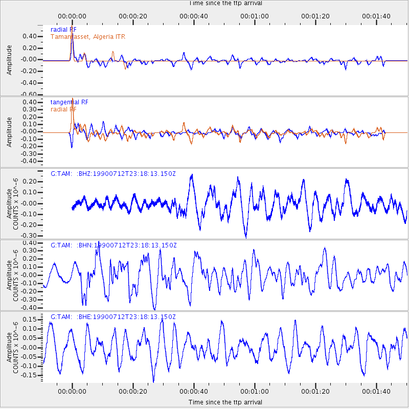
TAM Tamanrasset, Algeria - Earthquake Result Viewer
*The percent match for this event was below the threshold and hence no stack was calculated.
| Earthquake location: |
Windward Islands |
| Earthquake latitude/longitude: |
14.6/-60.5 |
| Earthquake time(UTC): |
1990/07/12 (193) 23:08:22 GMT |
| Earthquake Depth: |
27 km |
| Earthquake Magnitude: |
5.5 MB, 5.7 MS, 5.7 UNKNOWN, 5.7 MD |
| Earthquake Catalog/Contributor: |
WHDF/NEIC |
|
| Network: |
G GEOSCOPE |
| Station: |
TAM Tamanrasset, Algeria |
| Lat/Lon: |
22.79 N/5.53 E |
| Elevation: |
1377 m |
|
| Distance: |
62.6 deg |
| Az: |
71.714 deg |
| Baz: |
275.164 deg |
| Ray Param: |
$rayparam |
*The percent match for this event was below the threshold and hence was not used in the summary stack. |
|
| Radial Match: |
75.55404 % |
| Radial Bump: |
400 |
| Transverse Match: |
54.327335 % |
| Transverse Bump: |
386 |
| SOD ConfigId: |
4480 |
| Insert Time: |
2010-02-27 00:36:03.154 +0000 |
| GWidth: |
2.5 |
| Max Bumps: |
400 |
| Tol: |
0.001 |
|
Signal To Noise
| Channel | StoN | STA | LTA |
| G:TAM: :BHN:19900712T23:18:13.150Z | 1.9640825 | 1.7585012E-7 | 8.953295E-8 |
| G:TAM: :BHE:19900712T23:18:13.150Z | 1.4437319 | 8.159387E-8 | 5.6515944E-8 |
| G:TAM: :BHZ:19900712T23:18:13.150Z | 1.1249734 | 4.3853223E-8 | 3.898156E-8 |
| Arrivals |
| Ps | |
| PpPs | |
| PsPs/PpSs | |


