You are here: Home > Network List > CN - Canadian National Seismograph Network Stations List
> Station INK INUVIK, NT > Earthquake Result Viewer
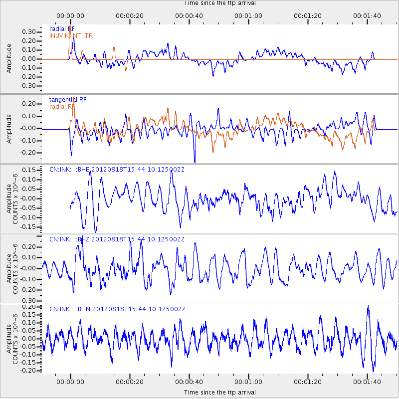
INK INUVIK, NT - Earthquake Result Viewer
*The percent match for this event was below the threshold and hence no stack was calculated.
| Earthquake location: |
Halmahera, Indonesia |
| Earthquake latitude/longitude: |
2.6/128.7 |
| Earthquake time(UTC): |
2012/08/18 (231) 15:31:40 GMT |
| Earthquake Depth: |
10 km |
| Earthquake Magnitude: |
5.8 MB, 5.5 MS, 5.8 MW, 5.8 MW |
| Earthquake Catalog/Contributor: |
WHDF/NEIC |
|
| Network: |
CN Canadian National Seismograph Network |
| Station: |
INK INUVIK, NT |
| Lat/Lon: |
68.31 N/133.53 W |
| Elevation: |
44 m |
|
| Distance: |
90.4 deg |
| Az: |
21.616 deg |
| Baz: |
278.195 deg |
| Ray Param: |
$rayparam |
*The percent match for this event was below the threshold and hence was not used in the summary stack. |
|
| Radial Match: |
50.166607 % |
| Radial Bump: |
400 |
| Transverse Match: |
61.65817 % |
| Transverse Bump: |
400 |
| SOD ConfigId: |
469095 |
| Insert Time: |
2013-02-22 07:05:42.233 +0000 |
| GWidth: |
2.5 |
| Max Bumps: |
400 |
| Tol: |
0.001 |
|
Signal To Noise
| Channel | StoN | STA | LTA |
| CN:INK: :BHZ:20120818T15:44:10.125002Z | 2.9849057 | 1.5413372E-7 | 5.1637716E-8 |
| CN:INK: :BHN:20120818T15:44:10.125002Z | 1.2837987 | 6.393965E-8 | 4.980505E-8 |
| CN:INK: :BHE:20120818T15:44:10.125002Z | 0.9948193 | 6.975675E-8 | 7.0120024E-8 |
| Arrivals |
| Ps | |
| PpPs | |
| PsPs/PpSs | |


