You are here: Home > Network List > G - GEOSCOPE Stations List
> Station TAM Tamanrasset, Algeria > Earthquake Result Viewer
TAM Tamanrasset, Algeria - Earthquake Result Viewer
*The percent match for this event was below the threshold and hence no stack was calculated.
| Earthquake location: |
Afghanistan-Tajikistan Bord Reg. |
| Earthquake latitude/longitude: |
36.4/71.1 |
| Earthquake time(UTC): |
2008/12/29 (364) 03:37:41 GMT |
| Earthquake Depth: |
158 km |
| Earthquake Magnitude: |
5.9 MB, 5.8 MW, 5.8 MW |
| Earthquake Catalog/Contributor: |
WHDF/NEIC |
|
| Network: |
G GEOSCOPE |
| Station: |
TAM Tamanrasset, Algeria |
| Lat/Lon: |
22.79 N/5.53 E |
| Elevation: |
1377 m |
|
| Distance: |
57.6 deg |
| Az: |
275.78 deg |
| Baz: |
60.434 deg |
| Ray Param: |
$rayparam |
*The percent match for this event was below the threshold and hence was not used in the summary stack. |
|
| Radial Match: |
77.391106 % |
| Radial Bump: |
400 |
| Transverse Match: |
68.0606 % |
| Transverse Bump: |
400 |
| SOD ConfigId: |
2658 |
| Insert Time: |
2010-02-27 00:36:05.801 +0000 |
| GWidth: |
2.5 |
| Max Bumps: |
400 |
| Tol: |
0.001 |
|
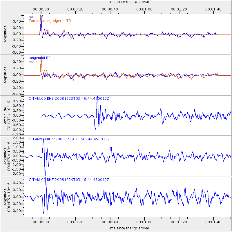
Signal To Noise
| Channel | StoN | STA | LTA |
| G:TAM:00:BHN:20081229T03:46:44.450012Z | 11.387708 | 1.0370121E-6 | 9.1064166E-8 |
| G:TAM:00:BHE:20081229T03:46:44.450012Z | 2.858371 | 2.5764098E-7 | 9.01356E-8 |
| G:TAM:00:BHZ:20081229T03:46:44.450012Z | 7.332578 | 5.483138E-7 | 7.477776E-8 |
| Arrivals |
| Ps | |
| PpPs | |
| PsPs/PpSs | |


