You are here: Home > Network List > TA - USArray Transportable Network (new EarthScope stations) Stations List
> Station G59A Clarenceville, QC, USA > Earthquake Result Viewer
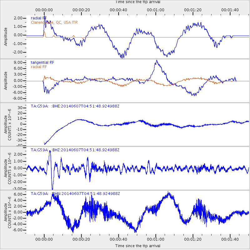
G59A Clarenceville, QC, USA - Earthquake Result Viewer
*The percent match for this event was below the threshold and hence no stack was calculated.
| Earthquake location: |
Northern Alaska |
| Earthquake latitude/longitude: |
67.9/-162.4 |
| Earthquake time(UTC): |
2014/06/07 (158) 04:43:34 GMT |
| Earthquake Depth: |
14 km |
| Earthquake Magnitude: |
6.0 MI |
| Earthquake Catalog/Contributor: |
NEIC PDE/NEIC ALERT |
|
| Network: |
TA USArray Transportable Network (new EarthScope stations) |
| Station: |
G59A Clarenceville, QC, USA |
| Lat/Lon: |
45.08 N/73.18 W |
| Elevation: |
36 m |
|
| Distance: |
48.9 deg |
| Az: |
69.986 deg |
| Baz: |
329.853 deg |
| Ray Param: |
$rayparam |
*The percent match for this event was below the threshold and hence was not used in the summary stack. |
|
| Radial Match: |
43.33908 % |
| Radial Bump: |
400 |
| Transverse Match: |
49.13923 % |
| Transverse Bump: |
400 |
| SOD ConfigId: |
3390531 |
| Insert Time: |
2019-04-12 04:51:18.239 +0000 |
| GWidth: |
2.5 |
| Max Bumps: |
400 |
| Tol: |
0.001 |
|
Signal To Noise
| Channel | StoN | STA | LTA |
| TA:G59A: :BHZ:20140607T04:51:48.924988Z | 6.1841526 | 1.5200364E-6 | 2.4579543E-7 |
| TA:G59A: :BHN:20140607T04:51:48.924988Z | 1.3320875 | 5.7953407E-6 | 4.3505706E-6 |
| TA:G59A: :BHE:20140607T04:51:48.924988Z | 0.2595132 | 3.6603478E-6 | 1.410467E-5 |
| Arrivals |
| Ps | |
| PpPs | |
| PsPs/PpSs | |


