You are here: Home > Network List > CI - Caltech Regional Seismic Network Stations List
> Station MPP McPhearson Peak > Earthquake Result Viewer
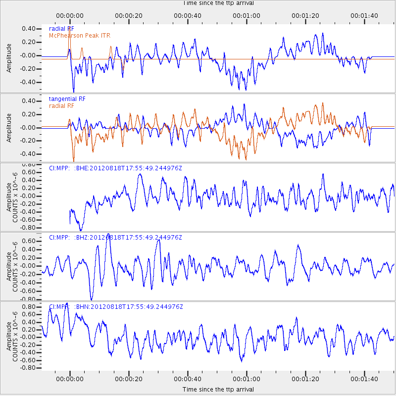
MPP McPhearson Peak - Earthquake Result Viewer
*The percent match for this event was below the threshold and hence no stack was calculated.
| Earthquake location: |
Tonga Islands |
| Earthquake latitude/longitude: |
-15.6/-173.0 |
| Earthquake time(UTC): |
2012/08/18 (231) 17:45:02 GMT |
| Earthquake Depth: |
15 km |
| Earthquake Magnitude: |
5.7 MW, 5.4 MS, 5.4 MB, 5.7 MW |
| Earthquake Catalog/Contributor: |
WHDF/NEIC |
|
| Network: |
CI Caltech Regional Seismic Network |
| Station: |
MPP McPhearson Peak |
| Lat/Lon: |
34.89 N/119.81 W |
| Elevation: |
1739 m |
|
| Distance: |
71.2 deg |
| Az: |
44.072 deg |
| Baz: |
234.621 deg |
| Ray Param: |
$rayparam |
*The percent match for this event was below the threshold and hence was not used in the summary stack. |
|
| Radial Match: |
26.985329 % |
| Radial Bump: |
400 |
| Transverse Match: |
23.490704 % |
| Transverse Bump: |
400 |
| SOD ConfigId: |
469095 |
| Insert Time: |
2013-02-22 07:11:23.464 +0000 |
| GWidth: |
2.5 |
| Max Bumps: |
400 |
| Tol: |
0.001 |
|
Signal To Noise
| Channel | StoN | STA | LTA |
| CI:MPP: :BHZ:20120818T17:55:49.244976Z | 1.0562251 | 1.6434618E-7 | 1.5559769E-7 |
| CI:MPP: :BHN:20120818T17:55:49.244976Z | 1.3051881 | 9.0517136E-7 | 6.9351796E-7 |
| CI:MPP: :BHE:20120818T17:55:49.244976Z | 1.0934721 | 3.4166803E-7 | 3.124616E-7 |
| Arrivals |
| Ps | |
| PpPs | |
| PsPs/PpSs | |


