You are here: Home > Network List > TA - USArray Transportable Network (new EarthScope stations) Stations List
> Station V41A Mountainview, AR, USA > Earthquake Result Viewer
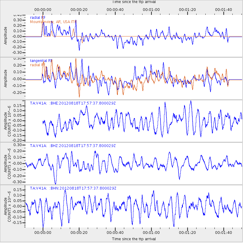
V41A Mountainview, AR, USA - Earthquake Result Viewer
*The percent match for this event was below the threshold and hence no stack was calculated.
| Earthquake location: |
Tonga Islands |
| Earthquake latitude/longitude: |
-15.6/-173.0 |
| Earthquake time(UTC): |
2012/08/18 (231) 17:45:02 GMT |
| Earthquake Depth: |
15 km |
| Earthquake Magnitude: |
5.7 MW, 5.4 MS, 5.4 MB, 5.7 MW |
| Earthquake Catalog/Contributor: |
WHDF/NEIC |
|
| Network: |
TA USArray Transportable Network (new EarthScope stations) |
| Station: |
V41A Mountainview, AR, USA |
| Lat/Lon: |
35.79 N/92.16 W |
| Elevation: |
413 m |
|
| Distance: |
91.8 deg |
| Az: |
53.437 deg |
| Baz: |
252.165 deg |
| Ray Param: |
$rayparam |
*The percent match for this event was below the threshold and hence was not used in the summary stack. |
|
| Radial Match: |
64.28793 % |
| Radial Bump: |
400 |
| Transverse Match: |
47.426605 % |
| Transverse Bump: |
400 |
| SOD ConfigId: |
469095 |
| Insert Time: |
2013-02-22 07:16:38.842 +0000 |
| GWidth: |
2.5 |
| Max Bumps: |
400 |
| Tol: |
0.001 |
|
Signal To Noise
| Channel | StoN | STA | LTA |
| TA:V41A: :BHZ:20120818T17:57:37.800029Z | 1.6171991 | 7.364493E-8 | 4.5538567E-8 |
| TA:V41A: :BHN:20120818T17:57:37.800029Z | 1.8341793 | 7.667379E-8 | 4.1802778E-8 |
| TA:V41A: :BHE:20120818T17:57:37.800029Z | 0.6960677 | 4.8602487E-8 | 6.982437E-8 |
| Arrivals |
| Ps | |
| PpPs | |
| PsPs/PpSs | |


