You are here: Home > Network List > TA - USArray Transportable Network (new EarthScope stations) Stations List
> Station U41A Viola, AR, USA > Earthquake Result Viewer
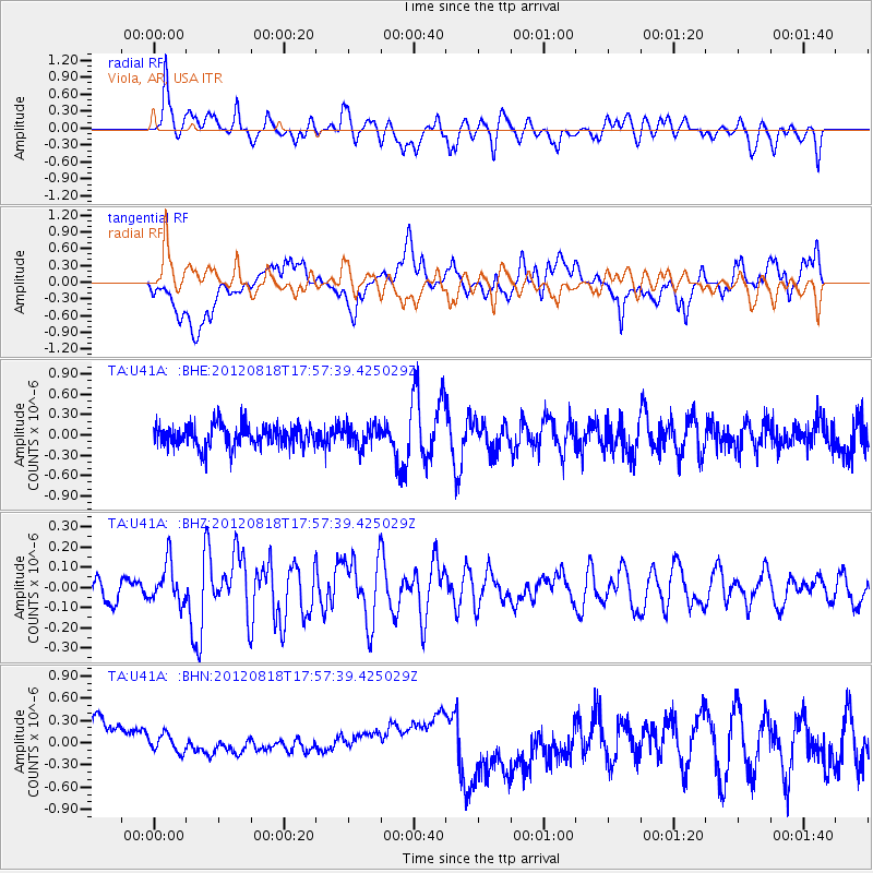
U41A Viola, AR, USA - Earthquake Result Viewer
*The percent match for this event was below the threshold and hence no stack was calculated.
| Earthquake location: |
Tonga Islands |
| Earthquake latitude/longitude: |
-15.6/-173.0 |
| Earthquake time(UTC): |
2012/08/18 (231) 17:45:02 GMT |
| Earthquake Depth: |
15 km |
| Earthquake Magnitude: |
5.7 MW, 5.4 MS, 5.4 MB, 5.7 MW |
| Earthquake Catalog/Contributor: |
WHDF/NEIC |
|
| Network: |
TA USArray Transportable Network (new EarthScope stations) |
| Station: |
U41A Viola, AR, USA |
| Lat/Lon: |
36.34 N/91.92 W |
| Elevation: |
300 m |
|
| Distance: |
92.2 deg |
| Az: |
52.964 deg |
| Baz: |
252.319 deg |
| Ray Param: |
$rayparam |
*The percent match for this event was below the threshold and hence was not used in the summary stack. |
|
| Radial Match: |
55.39486 % |
| Radial Bump: |
400 |
| Transverse Match: |
38.24023 % |
| Transverse Bump: |
400 |
| SOD ConfigId: |
469095 |
| Insert Time: |
2013-02-22 07:17:07.740 +0000 |
| GWidth: |
2.5 |
| Max Bumps: |
400 |
| Tol: |
0.001 |
|
Signal To Noise
| Channel | StoN | STA | LTA |
| TA:U41A: :BHZ:20120818T17:57:39.425029Z | 1.4934582 | 1.00161095E-7 | 6.706655E-8 |
| TA:U41A: :BHN:20120818T17:57:39.425029Z | 0.39611882 | 2.0062333E-7 | 5.0647265E-7 |
| TA:U41A: :BHE:20120818T17:57:39.425029Z | 0.9762137 | 1.5802453E-7 | 1.6187495E-7 |
| Arrivals |
| Ps | |
| PpPs | |
| PsPs/PpSs | |


