You are here: Home > Network List > TA - USArray Transportable Network (new EarthScope stations) Stations List
> Station 349A Repton, AL, USA > Earthquake Result Viewer
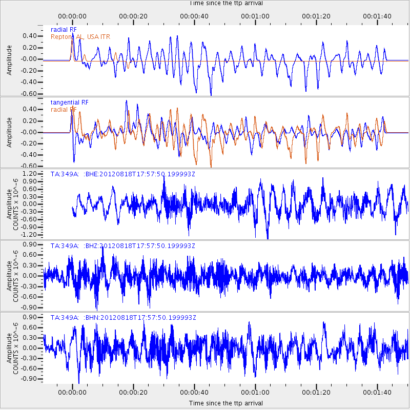
349A Repton, AL, USA - Earthquake Result Viewer
*The percent match for this event was below the threshold and hence no stack was calculated.
| Earthquake location: |
Tonga Islands |
| Earthquake latitude/longitude: |
-15.6/-173.0 |
| Earthquake time(UTC): |
2012/08/18 (231) 17:45:02 GMT |
| Earthquake Depth: |
15 km |
| Earthquake Magnitude: |
5.7 MW, 5.4 MS, 5.4 MB, 5.7 MW |
| Earthquake Catalog/Contributor: |
WHDF/NEIC |
|
| Network: |
TA USArray Transportable Network (new EarthScope stations) |
| Station: |
349A Repton, AL, USA |
| Lat/Lon: |
31.35 N/87.19 W |
| Elevation: |
88 m |
|
| Distance: |
94.5 deg |
| Az: |
58.866 deg |
| Baz: |
254.601 deg |
| Ray Param: |
$rayparam |
*The percent match for this event was below the threshold and hence was not used in the summary stack. |
|
| Radial Match: |
62.116043 % |
| Radial Bump: |
400 |
| Transverse Match: |
56.313915 % |
| Transverse Bump: |
400 |
| SOD ConfigId: |
469095 |
| Insert Time: |
2013-02-22 07:18:36.865 +0000 |
| GWidth: |
2.5 |
| Max Bumps: |
400 |
| Tol: |
0.001 |
|
Signal To Noise
| Channel | StoN | STA | LTA |
| TA:349A: :BHZ:20120818T17:57:50.199993Z | 1.6240284 | 3.0183497E-7 | 1.8585573E-7 |
| TA:349A: :BHN:20120818T17:57:50.199993Z | 2.1638775 | 4.2058863E-7 | 1.9436804E-7 |
| TA:349A: :BHE:20120818T17:57:50.199993Z | 1.3212266 | 3.7526004E-7 | 2.84024E-7 |
| Arrivals |
| Ps | |
| PpPs | |
| PsPs/PpSs | |


