You are here: Home > Network List > UW - Pacific Northwest Regional Seismic Network Stations List
> Station OMAK Colville Reservation, Omak, WA, USA > Earthquake Result Viewer
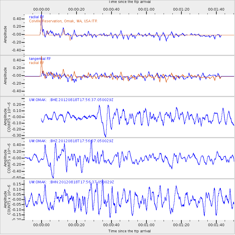
OMAK Colville Reservation, Omak, WA, USA - Earthquake Result Viewer
*The percent match for this event was below the threshold and hence no stack was calculated.
| Earthquake location: |
Tonga Islands |
| Earthquake latitude/longitude: |
-15.6/-173.0 |
| Earthquake time(UTC): |
2012/08/18 (231) 17:45:02 GMT |
| Earthquake Depth: |
15 km |
| Earthquake Magnitude: |
5.7 MW, 5.4 MS, 5.4 MB, 5.7 MW |
| Earthquake Catalog/Contributor: |
WHDF/NEIC |
|
| Network: |
UW Pacific Northwest Regional Seismic Network |
| Station: |
OMAK Colville Reservation, Omak, WA, USA |
| Lat/Lon: |
48.36 N/119.33 W |
| Elevation: |
696 m |
|
| Distance: |
79.6 deg |
| Az: |
33.137 deg |
| Baz: |
232.167 deg |
| Ray Param: |
$rayparam |
*The percent match for this event was below the threshold and hence was not used in the summary stack. |
|
| Radial Match: |
73.52206 % |
| Radial Bump: |
400 |
| Transverse Match: |
61.228767 % |
| Transverse Bump: |
400 |
| SOD ConfigId: |
469095 |
| Insert Time: |
2013-02-22 07:19:49.125 +0000 |
| GWidth: |
2.5 |
| Max Bumps: |
400 |
| Tol: |
0.001 |
|
Signal To Noise
| Channel | StoN | STA | LTA |
| UW:OMAK: :BHZ:20120818T17:56:37.050029Z | 3.5843694 | 1.6272112E-7 | 4.539742E-8 |
| UW:OMAK: :BHN:20120818T17:56:37.050029Z | 1.4768292 | 6.4376266E-8 | 4.3590866E-8 |
| UW:OMAK: :BHE:20120818T17:56:37.050029Z | 1.9518492 | 7.628965E-8 | 3.9085833E-8 |
| Arrivals |
| Ps | |
| PpPs | |
| PsPs/PpSs | |


