You are here: Home > Network List > AV - Alaska Volcano Observatory Stations List
> Station AMKA Regional Station, Amchitka Island, Alaska > Earthquake Result Viewer
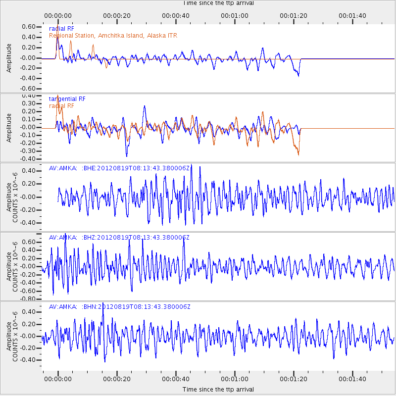
AMKA Regional Station, Amchitka Island, Alaska - Earthquake Result Viewer
*The percent match for this event was below the threshold and hence no stack was calculated.
| Earthquake location: |
Off Coast Of Washington |
| Earthquake latitude/longitude: |
47.8/-128.6 |
| Earthquake time(UTC): |
2012/08/19 (232) 08:07:35 GMT |
| Earthquake Depth: |
10 km |
| Earthquake Magnitude: |
5.6 MW, 5.3 MS, 5.2 MB, 5.5 MW |
| Earthquake Catalog/Contributor: |
WHDF/NEIC |
|
| Network: |
AV Alaska Volcano Observatory |
| Station: |
AMKA Regional Station, Amchitka Island, Alaska |
| Lat/Lon: |
51.38 N/179.30 E |
| Elevation: |
116 m |
|
| Distance: |
33.4 deg |
| Az: |
295.991 deg |
| Baz: |
75.27 deg |
| Ray Param: |
$rayparam |
*The percent match for this event was below the threshold and hence was not used in the summary stack. |
|
| Radial Match: |
51.31774 % |
| Radial Bump: |
400 |
| Transverse Match: |
50.32226 % |
| Transverse Bump: |
400 |
| SOD ConfigId: |
469095 |
| Insert Time: |
2013-02-22 07:22:05.172 +0000 |
| GWidth: |
2.5 |
| Max Bumps: |
400 |
| Tol: |
0.001 |
|
Signal To Noise
| Channel | StoN | STA | LTA |
| AV:AMKA: :BHZ:20120819T08:13:43.380006Z | 2.399246 | 3.2178517E-7 | 1.3411929E-7 |
| AV:AMKA: :BHN:20120819T08:13:43.380006Z | 1.5888847 | 1.5015003E-7 | 9.4500265E-8 |
| AV:AMKA: :BHE:20120819T08:13:43.380006Z | 1.6619927 | 2.0047764E-7 | 1.2062486E-7 |
| Arrivals |
| Ps | |
| PpPs | |
| PsPs/PpSs | |


