You are here: Home > Network List > TA - USArray Transportable Network (new EarthScope stations) Stations List
> Station Z48A Northport, AL, USA > Earthquake Result Viewer
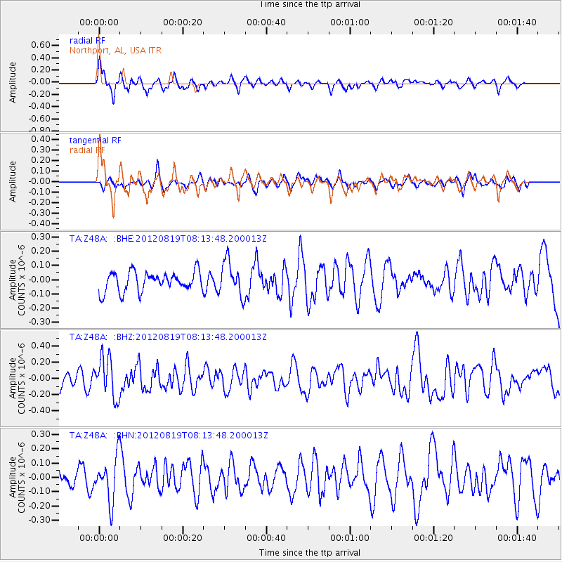
Z48A Northport, AL, USA - Earthquake Result Viewer
*The percent match for this event was below the threshold and hence no stack was calculated.
| Earthquake location: |
Off Coast Of Washington |
| Earthquake latitude/longitude: |
47.8/-128.6 |
| Earthquake time(UTC): |
2012/08/19 (232) 08:07:35 GMT |
| Earthquake Depth: |
10 km |
| Earthquake Magnitude: |
5.6 MW, 5.3 MS, 5.2 MB, 5.5 MW |
| Earthquake Catalog/Contributor: |
WHDF/NEIC |
|
| Network: |
TA USArray Transportable Network (new EarthScope stations) |
| Station: |
Z48A Northport, AL, USA |
| Lat/Lon: |
33.38 N/87.56 W |
| Elevation: |
101 m |
|
| Distance: |
33.9 deg |
| Az: |
99.971 deg |
| Baz: |
307.466 deg |
| Ray Param: |
$rayparam |
*The percent match for this event was below the threshold and hence was not used in the summary stack. |
|
| Radial Match: |
56.836063 % |
| Radial Bump: |
397 |
| Transverse Match: |
43.779705 % |
| Transverse Bump: |
400 |
| SOD ConfigId: |
469095 |
| Insert Time: |
2013-02-22 07:27:47.410 +0000 |
| GWidth: |
2.5 |
| Max Bumps: |
400 |
| Tol: |
0.001 |
|
Signal To Noise
| Channel | StoN | STA | LTA |
| TA:Z48A: :BHZ:20120819T08:13:48.200013Z | 3.46897 | 2.531578E-7 | 7.29778E-8 |
| TA:Z48A: :BHN:20120819T08:13:48.200013Z | 2.4376495 | 1.5808021E-7 | 6.4849445E-8 |
| TA:Z48A: :BHE:20120819T08:13:48.200013Z | 1.8040872 | 1.2347866E-7 | 6.8443846E-8 |
| Arrivals |
| Ps | |
| PpPs | |
| PsPs/PpSs | |


