You are here: Home > Network List > TA - USArray Transportable Network (new EarthScope stations) Stations List
> Station V43A Jonesboro, AR, USA > Earthquake Result Viewer
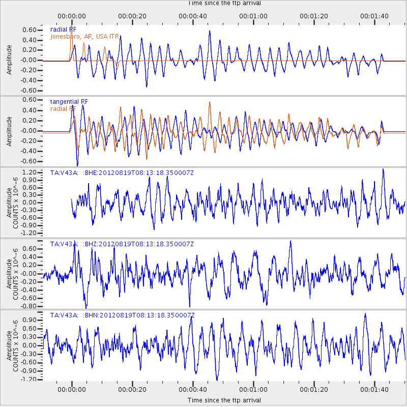
V43A Jonesboro, AR, USA - Earthquake Result Viewer
*The percent match for this event was below the threshold and hence no stack was calculated.
| Earthquake location: |
Off Coast Of Washington |
| Earthquake latitude/longitude: |
47.8/-128.6 |
| Earthquake time(UTC): |
2012/08/19 (232) 08:07:35 GMT |
| Earthquake Depth: |
10 km |
| Earthquake Magnitude: |
5.6 MW, 5.3 MS, 5.2 MB, 5.5 MW |
| Earthquake Catalog/Contributor: |
WHDF/NEIC |
|
| Network: |
TA USArray Transportable Network (new EarthScope stations) |
| Station: |
V43A Jonesboro, AR, USA |
| Lat/Lon: |
35.79 N/90.54 W |
| Elevation: |
74 m |
|
| Distance: |
30.5 deg |
| Az: |
99.071 deg |
| Baz: |
305.015 deg |
| Ray Param: |
$rayparam |
*The percent match for this event was below the threshold and hence was not used in the summary stack. |
|
| Radial Match: |
57.973484 % |
| Radial Bump: |
400 |
| Transverse Match: |
72.835075 % |
| Transverse Bump: |
400 |
| SOD ConfigId: |
469095 |
| Insert Time: |
2013-02-22 07:29:15.090 +0000 |
| GWidth: |
2.5 |
| Max Bumps: |
400 |
| Tol: |
0.001 |
|
Signal To Noise
| Channel | StoN | STA | LTA |
| TA:V43A: :BHZ:20120819T08:13:18.350007Z | 2.9649417 | 3.8747672E-7 | 1.3068612E-7 |
| TA:V43A: :BHN:20120819T08:13:18.350007Z | 0.93864363 | 3.3047962E-7 | 3.520821E-7 |
| TA:V43A: :BHE:20120819T08:13:18.350007Z | 1.4937617 | 5.135845E-7 | 3.4381958E-7 |
| Arrivals |
| Ps | |
| PpPs | |
| PsPs/PpSs | |


