You are here: Home > Network List > TA - USArray Transportable Network (new EarthScope stations) Stations List
> Station U44A Portageville, MO, USA > Earthquake Result Viewer
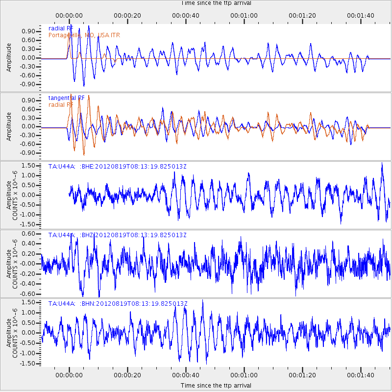
U44A Portageville, MO, USA - Earthquake Result Viewer
*The percent match for this event was below the threshold and hence no stack was calculated.
| Earthquake location: |
Off Coast Of Washington |
| Earthquake latitude/longitude: |
47.8/-128.6 |
| Earthquake time(UTC): |
2012/08/19 (232) 08:07:35 GMT |
| Earthquake Depth: |
10 km |
| Earthquake Magnitude: |
5.6 MW, 5.3 MS, 5.2 MB, 5.5 MW |
| Earthquake Catalog/Contributor: |
WHDF/NEIC |
|
| Network: |
TA USArray Transportable Network (new EarthScope stations) |
| Station: |
U44A Portageville, MO, USA |
| Lat/Lon: |
36.50 N/89.69 W |
| Elevation: |
89 m |
|
| Distance: |
30.7 deg |
| Az: |
97.137 deg |
| Baz: |
303.854 deg |
| Ray Param: |
$rayparam |
*The percent match for this event was below the threshold and hence was not used in the summary stack. |
|
| Radial Match: |
72.38697 % |
| Radial Bump: |
400 |
| Transverse Match: |
59.23389 % |
| Transverse Bump: |
400 |
| SOD ConfigId: |
469095 |
| Insert Time: |
2013-02-22 07:29:27.481 +0000 |
| GWidth: |
2.5 |
| Max Bumps: |
400 |
| Tol: |
0.001 |
|
Signal To Noise
| Channel | StoN | STA | LTA |
| TA:U44A: :BHZ:20120819T08:13:19.825013Z | 3.0980744 | 3.5038323E-7 | 1.13097094E-7 |
| TA:U44A: :BHN:20120819T08:13:19.825013Z | 1.2623231 | 4.7606213E-7 | 3.7713176E-7 |
| TA:U44A: :BHE:20120819T08:13:19.825013Z | 1.7485564 | 4.4482297E-7 | 2.5439442E-7 |
| Arrivals |
| Ps | |
| PpPs | |
| PsPs/PpSs | |


