You are here: Home > Network List > TA - USArray Transportable Network (new EarthScope stations) Stations List
> Station U48A Cassie Pea, Portland, TN, USA > Earthquake Result Viewer
U48A Cassie Pea, Portland, TN, USA - Earthquake Result Viewer
| Earthquake location: |
Off Coast Of Washington |
| Earthquake latitude/longitude: |
47.8/-128.6 |
| Earthquake time(UTC): |
2012/08/19 (232) 08:07:35 GMT |
| Earthquake Depth: |
10 km |
| Earthquake Magnitude: |
5.6 MW, 5.3 MS, 5.2 MB, 5.5 MW |
| Earthquake Catalog/Contributor: |
WHDF/NEIC |
|
| Network: |
TA USArray Transportable Network (new EarthScope stations) |
| Station: |
U48A Cassie Pea, Portland, TN, USA |
| Lat/Lon: |
36.51 N/86.54 W |
| Elevation: |
268 m |
|
| Distance: |
32.8 deg |
| Az: |
94.457 deg |
| Baz: |
303.439 deg |
| Ray Param: |
0.078502476 |
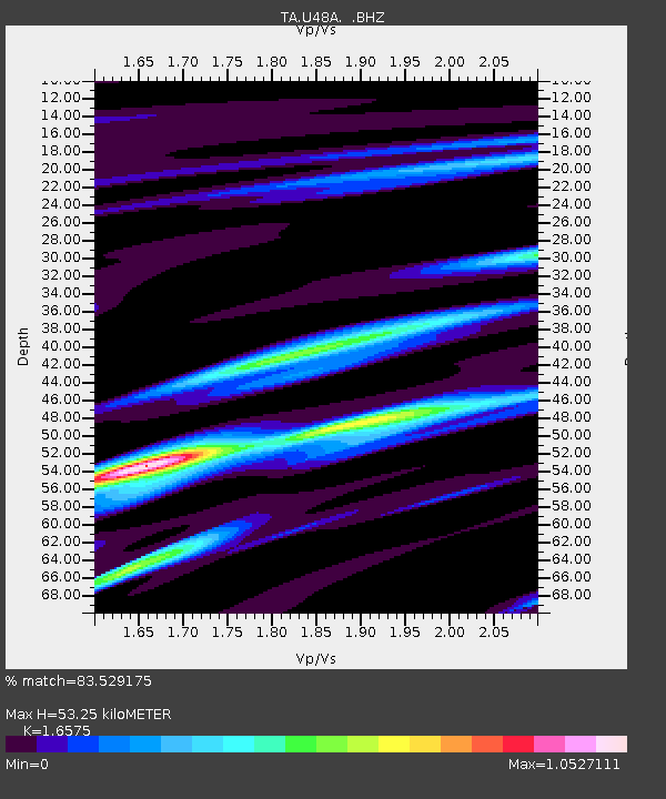
| Estimated Moho Depth: |
53.25 km |
| Estimated Crust Vp/Vs: |
1.66 |
| Assumed Crust Vp: |
6.444 km/s |
| Estimated Crust Vs: |
3.888 km/s |
| Estimated Crust Poisson's Ratio: |
0.21 |
|
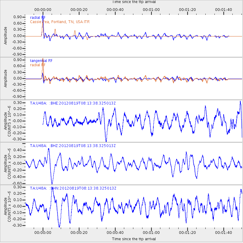
| Radial Match: |
83.529175 % |
| Radial Bump: |
400 |
| Transverse Match: |
40.65694 % |
| Transverse Bump: |
400 |
| SOD ConfigId: |
469095 |
| Insert Time: |
2013-02-22 07:31:57.860 +0000 |
| GWidth: |
2.5 |
| Max Bumps: |
400 |
| Tol: |
0.001 |
|
Signal To Noise
| Channel | StoN | STA | LTA |
| TA:U48A: :BHZ:20120819T08:13:38.325013Z | 2.7740324 | 2.3704868E-7 | 8.545275E-8 |
| TA:U48A: :BHN:20120819T08:13:38.325013Z | 1.5108211 | 9.752796E-8 | 6.455295E-8 |
| TA:U48A: :BHE:20120819T08:13:38.325013Z | 2.3940897 | 1.2160368E-7 | 5.0793286E-8 |
| Arrivals |
| Ps | 5.9 SECOND |
| PpPs | 20 SECOND |
| PsPs/PpSs | 26 SECOND |


